Category:Dorfkirche Mittweide
Jump to navigation
Jump to search
| Object location | | View all coordinates using: OpenStreetMap |
|---|
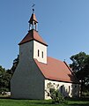
church building in Oder-Spree district, Germany  | |||||
| Upload media | |||||
| Instance of | |||||
|---|---|---|---|---|---|
| Location | Mittweide, Tauche, Oder-Spree District, Brandenburg, Germany | ||||
| Heritage designation | |||||
 | |||||
This is the category of the Brandenburger Baudenkmal (cultural heritage monument) with the ID 09115384 (Wikidata)
|
Media in category "Dorfkirche Mittweide"
The following 4 files are in this category, out of 4 total.
-
 Dorfkirche Mittweide 01.jpg 2,587 × 3,068; 2.14 MB
-
 Mittweide Dorfkirche 02.jpg 3,735 × 3,032; 9.42 MB
-
 Mittweide Dorfkirche 03.jpg 4,504 × 3,355; 8.87 MB
-
 Mittweide Dorfkirche 06.jpg 5,163 × 3,627; 12.54 MB


