Category:Dorfkirche Selchow (Storkow)
Jump to navigation
Jump to search
| Object location | | View all coordinates using: OpenStreetMap |
|---|
church building in Oder-Spree district, Brandenburg state, Germany _S%C3%BCdansicht.jpg) | |||||
| Upload media | |||||
| Instance of | |||||
|---|---|---|---|---|---|
| Location | Selchow, Storkow (Mark), Oder-Spree District, Brandenburg, Germany | ||||
| Heritage designation | |||||
 | |||||
This is the category of the Brandenburger Baudenkmal (cultural heritage monument) with the ID 09115184 (Wikidata)
|
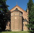
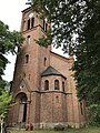
Deutsch: Evangelische Dorfkirche zu Selchow. Die denkmalgeschützte Kirche wurde 1865/66 nach Plänen von Friedrich August Stüler in neuromanischen Formen errichtet. Das Dorf Selchow ist ein Ortsteil der Brandenburger Kleinstadt Storkow im Landkreis Oder-Spree. Das 1321 erstmals urkundlich erwähnte Dorf hatte am 1. Januar 2013 259 Einwohner.
English: Protestant village church in Selchow. The listed church was built in 1865/66 in a neo-Romanesque style according to plans by Friedrich August Stüler. The village Selchow is a part of the town Storkow, District Oder-Spree, Brandenburg, Germany. The village was first mentioned in 1321 and had on January 1, 2013 259 inhabitants.
Subcategories
This category has only the following subcategory.
Media in category "Dorfkirche Selchow (Storkow)"
The following 11 files are in this category, out of 11 total.
-
 Dorfkirche Selchow (Storkow) 01.jpg 3,048 × 2,945; 3.33 MB
-
 Dorfkirche Selchow (Storkow) 02.jpg 1,676 × 2,071; 1.47 MB
-
 Dorfkirche Selchow (Storkow) 03.jpg 1,562 × 2,095; 1.05 MB
-
 Dorfkirche Selchow (Storkow) 04.jpg 3,135 × 2,739; 7.19 MB
-
 Dorfkirche Selchow (Storkow) Kirchenschiff Südansicht.jpg 4,032 × 3,024; 4.94 MB
-
 Dorfkirche Selchow (Storkow) Nordostansicht.jpg 4,032 × 3,024; 4.2 MB
-
 Dorfkirche Selchow (Storkow) Ostansicht.jpg 4,032 × 3,024; 3.8 MB
-
 Dorfkirche Selchow (Storkow) Südansicht.jpg 4,032 × 3,024; 4.39 MB
-
 Dorfkirche Selchow (Storkow) Westportal.jpg 3,024 × 4,032; 4.02 MB
-
 Dorfkirche Selchow (Storkow) Westturm Westansicht.jpg 3,024 × 4,032; 4.7 MB
-
 Dorfkirche Selchow Nordwestansicht.jpg 4,032 × 3,024; 4.5 MB
_01.jpg)
_02.jpg)
_03.jpg)
_04.jpg)
_Kirchenschiff_S%C3%BCdansicht.jpg)
_Nordostansicht.jpg)
_Ostansicht.jpg)
_Westportal.jpg)
_Westturm_Westansicht.jpg)
