Category:Eriz
Jump to navigation
Jump to search
municipality in the canton of Bern in Switzerland   | |||||
| Upload media | |||||
| Instance of | |||||
|---|---|---|---|---|---|
| Location |
| ||||
| Official language | |||||
| Population |
| ||||
| Area |
| ||||
| Elevation above sea level |
| ||||
| official website | |||||
 | |||||
Subcategories
This category has the following 2 subcategories, out of 2 total.
C
H
Media in category "Eriz"
The following 17 files are in this category, out of 17 total.
-
 42's Band Picture.jpg 4,096 × 2,726; 1.09 MB
-
 Alter Saumpfad Grünenbergpass Innereriz.jpg 6,000 × 4,000; 9.2 MB
-
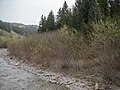 Auengebiet Innereriz beim Zulg, Horrenbach-Buchen BE– Eriz BE 20240408-jag9889.jpg 4,608 × 3,456; 11.1 MB
-
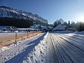 Before Sunset (60268364).jpeg 2,048 × 1,536; 1 MB
-
 CHE Eriz Flag.svg 800 × 800; 66 KB
-
 Eriz-coat of arms.svg 194 × 244; 28 KB
-
 Flachmoorgebiet Schwändli-Hungerschwand, Eriz BE 20240408-jag9889.jpg 4,608 × 3,456; 10.29 MB
-
 Flag of Eriz.gif 216 × 216; 7 KB
-
 Geisseggbrücke über den Fallbach, Horrenbach-Buchen BE – Innereriz BE 20210929-jag9889.jpg 4,344 × 3,258; 9.54 MB
-
 IMAG0675.jpg 3,024 × 4,032; 2.26 MB
-
 Kanton Bern - Honegg Hohgant.jpg 4,928 × 3,264; 7.55 MB
-
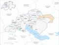 Karte Gemeinde Eriz 2007.png 1,181 × 899; 290 KB
-
 Karte Gemeinde Eriz 2010.png 1,476 × 1,149; 533 KB
-
 Karte Gemeinde Eriz.png 1,181 × 900; 252 KB
-
 Koppisbrücke über die Zulg, Horrenbach-Buchen BE – Eriz BE 20210929-jag9889.jpg 4,608 × 3,456; 15.01 MB
-
 Sichle Sichelpass.jpg 6,000 × 4,000; 7.23 MB
-
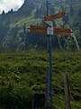 Swiss Hiking Routes - Signposts - Ober Breitwang.jpg 3,024 × 4,032; 2.49 MB


.jpeg)


