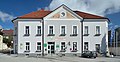
Category:Gemeindeamt Turnau
Jump to navigation
Jump to search
Deutsch: Gemeindeamt Turnau/Stmk.
| This category shows the protected monument with the number 124827 in Austria. (Commons, de, Wikidata) |
| Object location | | View all coordinates using: OpenStreetMap |
|---|
 | |||||
| Upload media | |||||
| Instance of | |||||
|---|---|---|---|---|---|
| Location | Turnau, Bruck-Mürzzuschlag District, Styria, Austria | ||||
| Street address |
| ||||
| Heritage designation | |||||
 | |||||
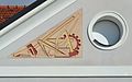
Media in category "Gemeindeamt Turnau"
The following 5 files are in this category, out of 5 total.
-
 Gemeindeamt Turnau 01.jpg 4,704 × 2,586; 3.86 MB
-
 Gemeindeamt Turnau 02.jpg 4,649 × 2,902; 4.14 MB
-
 Gemeindeamt Turnau 03.jpg 4,614 × 2,832; 4.36 MB
-
 Gemeindeamt Turnau 04.jpg 4,520 × 2,344; 3.41 MB
-
 Gemeindeamt Turnau.JPG 1,280 × 960; 562 KB


