Category:Kalvarienbergkirche Breitegg
Jump to navigation
Jump to search
| Object location | | View all coordinates using: OpenStreetMap |
|---|
| This category shows the protected monument with the number 99816 in Austria. (Commons, de, Wikidata) |
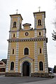
church building in Styria, Austria  | |||||
| Upload media | |||||
| Instance of | |||||
|---|---|---|---|---|---|
| Location | Sankt Ruprecht an der Raab, Weiz District, Styria, Austria | ||||
| Street address |
| ||||
| Heritage designation | |||||
 | |||||
Subcategories
This category has only the following subcategory.
K
Media in category "Kalvarienbergkirche Breitegg"
The following 5 files are in this category, out of 5 total.
-
 Breitegg Me 082.jpg 2,496 × 1,664; 2.04 MB
-
 Kalvarienbergkirche Breitegg 01.jpg 3,626 × 5,438; 6.5 MB
-
 Kalvarienbergkirche Breitegg 02.jpg 3,758 × 5,637; 6.07 MB
-
 Kalvarienbergkirche Breitegg 03.jpg 4,000 × 6,000; 10.52 MB
-
 Wallfahrtskirche Breitegg Me 028.jpg 1,023 × 1,535; 840 KB


