Category:Klagenfurt, Villacher Ring 11
Jump to navigation
Jump to search
| Object location | | View all coordinates using: OpenStreetMap |
|---|
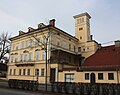
building in Klagenfurt, Austria  | |||||
| Upload media | |||||
| Instance of | |||||
|---|---|---|---|---|---|
| Location | Klagenfurt am Wörthersee, Carinthia, Austria | ||||
| Street address |
| ||||
| Heritage designation | |||||
 | |||||
Media in category "Klagenfurt, Villacher Ring 11"
The following 7 files are in this category, out of 7 total.
-
 Klagenfurt Villacher Ring 11 Architekt Venchiarutti 31072008 60.jpg 3,648 × 2,172; 1.23 MB
-
 Klagenfurt Villacher Ring 11 Nebengebaeude 02082016 3426.jpg 6,799 × 4,538; 10.38 MB
-
 Klagenfurt Villacher Ring 11 Villa Venchiarutti 02082016 3419.jpg 7,360 × 4,912; 15.96 MB
-
 Klagenfurt Villacher Ring 11 Villa Venchiarutti 02082016 3420.jpg 4,912 × 4,993; 10.64 MB
-
 Klagenfurt Villacher Ring 11 Villa Venchiarutti 02082016 3433.jpg 5,461 × 4,807; 14.5 MB
-
 Klagenfurt Villacher Ring 11 Villa Venchiarutti Balkon 02082016 3424.jpg 6,029 × 3,606; 7.59 MB
-
 Klagenfurt - Villacher Ring 13.jpg 3,526 × 2,789; 2.03 MB


