Category:Moni Agiou Antoniou Vrontisiou
Jump to navigation
Jump to search
The Vrontisiou Monastery, it was founded during the Second Byzantine Period (tenth to thirteenth centuries). 50 km away from Heraklion, lies on the south slope of the Psiloritis Mountain, a little to the north-west of the village of Zaros (Crete).
| Object location | | View all coordinates using: OpenStreetMap |
|---|
Polski: Klasztor Vrontisi na Krecie (50 km od Heraklionu)
Ελληνικά: Μονή Αγίου Αντωνίου Βροντησίου, Κρήτη
Greek monastery in Crete  | |||||
| Upload media | |||||
| Instance of | |||||
|---|---|---|---|---|---|
| Location |
| ||||
| Heritage designation |
| ||||
| Inception |
| ||||
| Population |
| ||||
 | |||||
Media in category "Moni Agiou Antoniou Vrontisiou"
The following 8 files are in this category, out of 8 total.
-
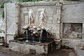
 Vrontisi monastery fountain.JPG 2,048 × 1,536; 691 KB
-
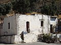 Vrontisi monastery old cells.JPG 2,048 × 1,536; 780 KB
-
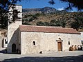 Vrontisi monastery St. Antony church.JPG 2,048 × 1,536; 961 KB
-
 Vrontisi1(js).jpg 3,888 × 2,592; 4.88 MB
-
 Vrontisi2(js).jpg 3,888 × 2,592; 5.31 MB
-
 Vrontisi3(js).jpg 3,888 × 2,592; 4.92 MB
-
 Καθολικό μονής Βροντησίου 8798.jpg 4,022 × 3,134; 6.88 MB
-
 Κρήνη Μονής Βροντησίου 8789.jpg 4,632 × 3,294; 8.74 MB


.jpg)
.jpg)
.jpg)

