Category:Pfarrhof St. Peter (Rankweil)
Jump to navigation
Jump to search
| Object location | | View all coordinates using: OpenStreetMap |
|---|
 | |||||
| Upload media | |||||
| Instance of | |||||
|---|---|---|---|---|---|
| Location | Rankweil, Feldkirch District, Vorarlberg, Austria | ||||
| Street address |
| ||||
| Heritage designation | |||||
 | |||||
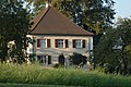
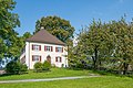
Deutsch: der Pfarrhof St. Peter am St.-Peter-Bühel Nr.1, Rankweil.
Media in category "Pfarrhof St. Peter (Rankweil)"
The following 4 files are in this category, out of 4 total.
-
 Pfarrhof St. Peter Bühel.jpg 3,008 × 2,000; 2.67 MB
-
 St.-Peter-Bühel 1, Rankweil 01.JPG 6,163 × 4,109; 22.73 MB
-
 St.-Peter-Bühel 1, Rankweil 02.JPG 5,576 × 3,717; 21.78 MB
-
 St.-Peter-Bühel 1, Rankweil 03.JPG 6,576 × 4,384; 26.31 MB


