Category:Pfarrkirche Traunfeld
Jump to navigation
Jump to search
| Object location | | View all coordinates using: OpenStreetMap |
|---|
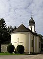
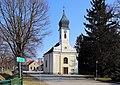
church building in Hochleithen, Austria   | |||||
| Upload media | |||||
| Instance of | |||||
|---|---|---|---|---|---|
| Named after | |||||
| Location | Hochleithen, Mistelbach District, Lower Austria, Austria | ||||
| Street address |
| ||||
| Architectural style | |||||
| Diocese | |||||
| Heritage designation | |||||
 | |||||
| This category shows the protected monument with the number 20899 in Austria. (Commons, de, Wikidata) |
Deutsch: Kath. Filialkirche hl. Johannes Nepomuk in Traunfeld, Gemeinde Hochleithen, Niederösterreich.
Media in category "Pfarrkirche Traunfeld"
The following 5 files are in this category, out of 5 total.
-
 Kirche Traunfeld 4357C2.JPG 2,180 × 2,964; 1.34 MB
-
 Kirche Traunfeld.JPG 2,472 × 3,708; 1.53 MB
-
 Traunfeld - Kirche, innen.JPG 2,931 × 1,954; 3.77 MB
-
 Traunfeld - Kirche.JPG 3,543 × 2,506; 9.13 MB
-
 Traunfeld Filialkirche.jpg 1,920 × 1,280; 460 KB


