Category:Pfarrkirche hl. Leonhard, Zwickenberg, Oberdrauburg
Jump to navigation
Jump to search
| Object location | | View all coordinates using: OpenStreetMap |
|---|
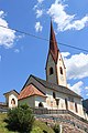
parish church with cemetery in Oberdrauburg, Austria   | |||||
| Upload media | |||||
| Instance of | |||||
|---|---|---|---|---|---|
| Location | Oberdrauburg, Spittal an der Drau District, Carinthia, Austria | ||||
| Street address |
| ||||
| Heritage designation | |||||
 | |||||
Subcategories
This category has the following 2 subcategories, out of 2 total.
Media in category "Pfarrkirche hl. Leonhard, Zwickenberg, Oberdrauburg"
The following 22 files are in this category, out of 22 total.
-
 Kath. Pfarrkirche hl. Leonhard und Friedhof 000.jpg 6,000 × 4,000; 9.53 MB
-
 Kath. Pfarrkirche hl. Leonhard und Friedhof 001.jpg 1,425 × 1,000; 836 KB
-
 Kath. Pfarrkirche hl. Leonhard und Friedhof 003.jpg 2,982 × 3,784; 4.26 MB
-
 Kath. Pfarrkirche hl. Leonhard und Friedhof 004.jpg 2,473 × 3,835; 3.7 MB
-
 Kath. Pfarrkirche hl. Leonhard und Friedhof 005.jpg 6,000 × 3,957; 7.35 MB
-
 Kath. Pfarrkirche hl. Leonhard und Friedhof 006.jpg 5,720 × 3,477; 8.58 MB
-
 Kath. Pfarrkirche hl. Leonhard und Friedhof 007.jpg 1,411 × 3,642; 1.33 MB
-
 Kath. Pfarrkirche hl. Leonhard und Friedhof 008.jpg 5,921 × 4,000; 7.95 MB
-
 Kath. Pfarrkirche hl. Leonhard und Friedhof 009.jpg 6,000 × 4,000; 21.27 MB
-
 Marktgemeinde Oberdrauburg, Zwickenberg Kriegerdenkmal, Kärnten.jpg 5,921 × 3,914; 7.95 MB
-
 Oberdrauburg Zwickenberg West-Ansicht 24092006 01.jpg 3,872 × 2,592; 1.65 MB
-
 Pfarrkirche Hl. Leonhard Zwickenberg 1.jpg 4,000 × 3,000; 2.91 MB
-
 Pfarrkirche Hl. Leonhard Zwickenberg 2.jpg 4,000 × 3,000; 3.12 MB
-
 Pfarrkirche St. Leonhard Zwickenberg 3.jpg 4,000 × 3,000; 3.24 MB
-
 Pfarrkirche St. Leonhard Zwickenberg 4.jpg 3,000 × 4,000; 3.28 MB
-
 Pfarrkirche Zwickenberg - Fresko.JPG 5,184 × 1,597; 4.57 MB
-
 Pfarrkirche Zwickenberg - Kreuzigungsfresko.JPG 4,049 × 3,184; 8.3 MB
-
 Pfarrkirche Zwickenberg - Portal.JPG 3,456 × 5,184; 8.36 MB
-
 Pfarrkirche Zwickenberg3.JPG 3,456 × 5,184; 6.28 MB
-
 Pfarrkirche Zwickenberg4.JPG 5,184 × 3,456; 6.36 MB
-
 Zwickenberg - Pfarrkirche1.JPG 3,456 × 5,184; 3.54 MB
-
 Zwickenberg -Pfarrkirche2.JPG 3,456 × 5,184; 3.56 MB


Categories:
- 13th-century architecture in Carinthia
- 14th-century architecture in Carinthia
- 15th-century architecture in Carinthia
- Beige churches in Carinthia
- Churches in the Roman Catholic Diocese of Gurk
- Churches in Bezirk Spittal an der Drau
- Cultural heritage monuments in Oberdrauburg
- Deanery Greifenburg
- Gothic churches in Carinthia
- Saint Leonard churches in Carinthia
- Oberes Drautal
- Parish churches in Carinthia
- Zwickenberg
- Cemeteries in Bezirk Spittal an der Drau