Category:Pfarrkirche hl. Nikolaus, Gradenegg (Liebenfels)
Jump to navigation
Jump to search
| Object location | | View all coordinates using: OpenStreetMap |
|---|
parish church with cemetery in Liebenfels, Austria  | |||||
| Upload media | |||||
| Instance of | |||||
|---|---|---|---|---|---|
| Named after | |||||
| Location | Liebenfels, Sankt Veit an der Glan District, Carinthia, Austria | ||||
| Street address |
| ||||
| Heritage designation | |||||
 | |||||
Subcategories
This category has only the following subcategory.
Pages in category "Pfarrkirche hl. Nikolaus, Gradenegg (Liebenfels)"
This category contains only the following page.
Media in category "Pfarrkirche hl. Nikolaus, Gradenegg (Liebenfels)"
The following 8 files are in this category, out of 8 total.
-
 Gradenegg - Kirche Sonnenuhr.jpg 4,150 × 3,446; 4.59 MB
-
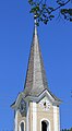 Gradenegg - Kirchturm.jpg 2,813 × 5,123; 2.83 MB
-
 Gradenegg - Pfarrkirche -Kruzifix.JPG 2,900 × 4,790; 8.35 MB
-
 Gradenegg - Pfarrkirche1.JPG 3,309 × 3,405; 4.8 MB
-
 Gradenegg - Pfarrkirche2.JPG 3,077 × 4,613; 7.23 MB
-
 Gradenegg - Pfarrkirche3.JPG 2,620 × 5,059; 6.56 MB
-
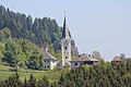 Gradenegg.JPG 5,184 × 3,456; 6.21 MB
-
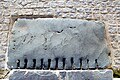 Liebenfels Gradenegg Pfarrkirche hl. Nikolaus keltischer Schwellenstein 09042007 02.jpg 3,872 × 2,592; 2.16 MB


Categories:
- 14th-century architecture in Carinthia
- Beige churches in Carinthia
- Churches in Liebenfels
- Churches in the Roman Catholic Diocese of Gurk
- Cultural heritage monuments in Liebenfels
- Deanery St. Veit an der Glan
- Gothic churches in Carinthia
- Gradenegg (Liebenfels)
- Romanesque churches in Carinthia
- Saint Nicholas churches in Carinthia