Category:Rotkreuzkapelle, Hartberg
Jump to navigation
Jump to search
| Object location | | View all coordinates using: OpenStreetMap |
|---|
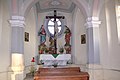
building in Hartberg, Austria  | |||||
| Upload media | |||||
| Instance of | |||||
|---|---|---|---|---|---|
| Location | Hartberg, Hartberg-Fürstenfeld District, Styria, Austria | ||||
| Street address |
| ||||
| Heritage designation | |||||
 | |||||
Deutsch: Hartberg sogenannte Rot-Kreuz Kapelle
Media in category "Rotkreuzkapelle, Hartberg"
The following 6 files are in this category, out of 6 total.
-
 Hartberg-RotKreuzKapelle 3015.jpg 2,362 × 3,540; 1.08 MB
-
 Hartberg-RotKreuzKapelle 3393.JPG 3,888 × 2,592; 2.66 MB
-
 Hartberg-RotKreuzKapelle 3396.jpg 2,384 × 3,583; 775 KB
-
 Hartberg-RotKreuzKapelle 3397.jpg 2,311 × 3,474; 804 KB
-
 Hartberg-RotKreuzKapelle 3401.jpg 3,906 × 2,602; 716 KB
-
 Hartberg-RotKreuzKapelle 3409.jpg 722 × 481; 74 KB


