Category:Ruine Frohnberg, Miesenbach
Jump to navigation
Jump to search
| This category shows the protected monument with the number 27066 in Austria. (Commons, de, Wikidata) |
| Object location | | View all coordinates using: OpenStreetMap |
|---|
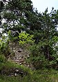
.jpg) Eine der spärlichen Mauerreste der Ruine Frohnberg | |||||
| Upload media | |||||
| Instance of | |||||
|---|---|---|---|---|---|
| Location | Miesenbach, Wiener Neustadt District, Lower Austria, Austria | ||||
| Heritage designation | |||||
 | |||||
Media in category "Ruine Frohnberg, Miesenbach"
The following 4 files are in this category, out of 4 total.
-
 Frohnberg - Ruine, Mauerrest (1).jpg 3,543 × 2,362; 8.84 MB
-
 Frohnberg - Ruine, Mauerrest (2).jpg 2,505 × 3,542; 12.51 MB
-
 Frohnberg - Ruine, Standort.jpg 3,543 × 2,362; 6.91 MB
-
 Standort der Ruine Frohnberg 27066 in A-2761 Frohnberg.jpg 2,736 × 3,648; 3.43 MB
.jpg)

