Category:Saint Barbara Church (Wiesen, Burgenland)
Jump to navigation
Jump to search
| Object location | | View all coordinates using: OpenStreetMap |
|---|
| This category shows the protected monument with the number 20504 in Austria. (Commons, de, Wikidata) |
church _-_Ehemalige_Pfarrkirche_hl._Barbara_(02).jpg) | |||||
| Upload media | |||||
| Instance of | |||||
|---|---|---|---|---|---|
| Named after | |||||
| Location | Wiesen, Mattersburg District, Burgenland, Austria | ||||
| Heritage designation | |||||
 | |||||
Media in category "Saint Barbara Church (Wiesen, Burgenland)"
The following 5 files are in this category, out of 5 total.
-
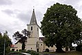
 Saint Barbara Church Wiesen Burgenland 01.jpg 6,000 × 4,000; 8.94 MB
-
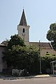
 Wiesen (Burgenland) - Ehemalige Pfarrkirche hl. Barbara (01).jpg 2,000 × 3,000; 845 KB
-
 Wiesen (Burgenland) - Ehemalige Pfarrkirche hl. Barbara (02).jpg 3,000 × 2,000; 1.39 MB
-
 Wiesen 5119.JPG 3,254 × 4,881; 941 KB
-
 Wiesen-ehemPfarrkirche 5134.JPG 3,278 × 4,917; 1.3 MB

_-_Ehemalige_Pfarrkirche_hl._Barbara_(01).jpg)

