Category:Samar Island
Jump to navigation
Jump to search
island in the Philippines   | |||||
| Upload media | |||||
| Instance of | |||||
|---|---|---|---|---|---|
| Part of | |||||
| Location | Eastern Visayas, PH | ||||
| Located in or next to body of water |
| ||||
| Population |
| ||||
| Area |
| ||||
| Elevation above sea level |
| ||||
 | |||||
Subcategories
This category has the following 4 subcategories, out of 4 total.
E
N
P
S
Media in category "Samar Island"
The following 52 files are in this category, out of 52 total.
-
 Admiralty Chart No 3370 San Bernardino Strait, Published 1924.jpg 16,400 × 11,275; 50.86 MB
-
 Another form of attractive stalagmites.jpg 1,024 × 768; 238 KB
-
 Beach Marabut Samar.jpg 3,072 × 2,048; 2.83 MB
-
 Brilliant stalagmites with reflective crystalline surface.jpg 1,086 × 724; 258 KB
-
 Cape Espiritu Santu in Samar.jpg 640 × 480; 49 KB
-
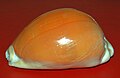 Cypraea aurantium - Samar.JPG 862 × 558; 33 KB
-
 Etrance to the Langun - Gobingob cave.jpg 1,086 × 724; 486 KB
-
 Fresh Oysters.jpg 720 × 404; 115 KB
-
 Inside the largest cave in Samar.jpg 1,086 × 724; 264 KB
-
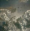 Islands of Samar and Leyte from space.jpg 470 × 475; 33 KB
-
 Langun Gobingob cave stalactites, shown to scale against 2 persons.jpg 1,024 × 768; 199 KB
-
 Langun-Gobingob cave in Samar.jpg 1,086 × 724; 213 KB
-
 Langun-Gobingob cave showing huge stalactites almost reaching the floor.jpg 1,086 × 724; 188 KB
-
 Langun-Gobingob cave stalactites.jpg 1,024 × 768; 159 KB
-
 Langun-Gobingob cave, trek back to Calbiga.jpg 1,024 × 768; 346 KB
-
 Langun-Gobingob Cave.jpg 1,024 × 768; 155 KB
-
 Ph locator map samar island-ar.png 300 × 440; 38 KB
-
 Ph locator map samar island.png 300 × 440; 23 KB
-
 Lyncina aurantium (6477929309).jpg 1,868 × 1,428; 237 KB
-
 Lyncina aurantium (6477933695).jpg 2,187 × 1,623; 310 KB
-
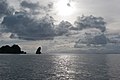
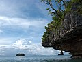 Marabut, Philippines, Limestone formations in the sea 2.jpg 4,000 × 3,000; 6.5 MB
-
 Marabut, Philippines, Limestone formations in the sea.jpg 4,000 × 3,000; 6.6 MB
-
 Marabut, Philippines, Limestone formations.jpg 4,000 × 3,000; 7.83 MB
-
 Marabut, Philippines, Limestone islands in San Pedro Bay 2.jpg 4,000 × 2,667; 5.97 MB
-
 Marabut, Philippines, Limestone islands in San Pedro Bay.jpg 4,000 × 2,667; 7.15 MB
-
 Marabut, Philippines, Limestone islands in the sea.jpg 4,000 × 2,667; 5.89 MB
-
 Marabut, Philippines, Limestone outcrops, Pacific Ocean.jpg 4,000 × 2,667; 5.77 MB
-
 Marabut, Philippines, Limestone outcrops.jpg 4,000 × 2,667; 6.19 MB
-
 Marabut, Philippines, Limestone rocks in the sea.jpg 4,000 × 2,667; 5.7 MB
-
 Marabut, Philippines, Marabut coastline, San Pedro Bay.jpg 4,000 × 3,000; 7.39 MB
-
 Marabut, Philippines, Marabut coastline.jpg 4,000 × 2,667; 6.03 MB
-
 Marabut, Philippines, Rocky limestone outcrops.jpg 4,000 × 2,667; 5.71 MB
-
 Marabut, Philippines, San Pedro Bay.jpg 4,000 × 2,667; 6.23 MB
-
 Marabut, Philippines, Tropical sky in Pacific Ocean.jpg 4,000 × 2,667; 5.75 MB
-
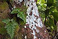 Marabut, Philippines, Tropical wood, moss and leaves.jpg 4,000 × 2,667; 8.04 MB
-
 Rock formation Marabut Samar.jpg 3,072 × 2,048; 4.35 MB
-
 Samar Island Location Map Red.png 2,000 × 3,120; 211 KB
-
 Samar Island, Philippines.jpg 4,000 × 2,667; 6.07 MB
-
 Samar Island.png 600 × 692; 155 KB
-
 Samar, American Standard, Philippines.jpg 4,000 × 2,667; 8.8 MB
-
 Samar, Bed, Philippines.jpg 4,000 × 3,000; 8.37 MB
-
 Samar, Fishing, Twilight sky, Philippines.jpg 4,000 × 3,000; 6.61 MB
-
 Samar, Fishing, Twilight, Philippines.jpg 4,000 × 3,000; 6.73 MB
-
 Samar, Marabut coast, Philippines.jpg 4,000 × 2,667; 6.98 MB
-
 Samar, Marabut coastline, Philippines.jpg 4,000 × 2,667; 7.33 MB
-
 Samar, Pacific Kayak, Clarks Shoes, Philippines.jpg 4,000 × 3,000; 9.04 MB
-
 Samar, Rainbow, Philippines.jpg 4,000 × 2,667; 6.61 MB
-
 Samar, Tropical lawn, Philippines.jpg 4,000 × 2,667; 7.08 MB
-
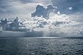
 Samar, Tropical sky, Clouds, Philippines.jpg 4,000 × 2,667; 5.18 MB
-
 Samar, Tropical sky, Twilight, Philippines.jpg 4,000 × 2,667; 5.52 MB
-
 Stalagmite looking like a stack of mushrooms.jpg 724 × 1,086; 267 KB
-
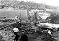 VMF-222 Corsair crash.jpg 600 × 418; 197 KB


.jpg)
.jpg)


