Category:Türkenmarterl Kotzendorf
Jump to navigation
Jump to search
| Object location | | View all coordinates using: OpenStreetMap |
|---|
 | |||||
| Upload media | |||||
| Instance of | |||||
|---|---|---|---|---|---|
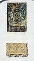
| Depicts | Pietà | ||||
| Location | Kotzendorf, Gars am Kamp, Horn District, Lower Austria, Austria | ||||
| Heritage designation | |||||
 | |||||
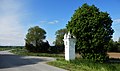
Deutsch: Bildstock "Türkenmarterl" bei Kotzendorf, Gemeinde Gars am Kamp, Niederösterreich, Österreich
English: Wayside shrine "Türkenmarterl" near Kotzendorf, Municipality Gars am Kamp, Lower Austria, Austria
Media in category "Türkenmarterl Kotzendorf"
The following 6 files are in this category, out of 6 total.
-
 Kotzendorf Raaberkreuz 2020 01.jpg 4,608 × 2,744; 2.14 MB
-
 Kotzendorf Raaberkreuz 2020 02 Pieta.jpg 3,456 × 4,608; 3.17 MB
-
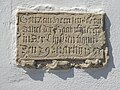 Kotzendorf Raaberkreuz 2020 03 Inschrift.jpg 4,608 × 3,456; 3.27 MB
-
 Kotzendorf Türkenmarterl Detail.jpg 2,230 × 3,923; 5.71 MB
-
 Kotzendorf Türkenmarterl.jpg 2,146 × 3,946; 5.08 MB
-
 Türkenmarterl 73211 bei A-3571 Kotzendorf.jpg 4,000 × 6,000; 3.83 MB


