Category:Todesco monument Gramatneusiedl
Jump to navigation
Jump to search
| Object location | | View all coordinates using: OpenStreetMap |
|---|
 | |||||
| Upload media | |||||
| Instance of | |||||
|---|---|---|---|---|---|
| Location | Gramatneusiedl, Bruck an der Leitha District, Lower Austria, Austria | ||||
| Street address |
| ||||
| Heritage designation | |||||
 | |||||
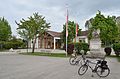
Deutsch: Todesco-Denkmal in Gramatneusiedl, errichtet um 1866. Renoviert von Karl Martin Sukopp.
Media in category "Todesco monument Gramatneusiedl"
The following 11 files are in this category, out of 11 total.
-
 Gramatneusiedl Todesco 3657.jpg 3,456 × 5,184; 8.49 MB
-
 Gramatneusiedl Todesco 3658.jpg 3,456 × 5,184; 7.38 MB
-
 Maria-Johoda-Platz Gramatneusiedl.jpg 4,812 × 3,180; 6.85 MB
-
 Todesco monument - angel's left wing.jpg 3,264 × 4,928; 9.82 MB
-
 Todesco monument - angel's right wing.jpg 3,264 × 4,928; 6.66 MB
-
 Todesco monument - plaque.jpg 3,900 × 2,628; 5.33 MB
-
 Todesco monument Gramatneusiedl - relief 01.jpg 4,328 × 2,950; 5.84 MB
-
 Todesco monument Gramatneusiedl - relief 02.jpg 4,264 × 2,848; 5.49 MB
-
 Todesco monument Gramatneusiedl - relief 03.jpg 3,871 × 2,624; 4.59 MB
-
 Todesco monument Gramatneusiedl.jpg 4,096 × 3,264; 5.87 MB
-
 Todesco-Denkmal in Gramatneusiedl 2011.jpg 1,024 × 768; 791 KB


