User:Ulanwp
Jump to navigation
Jump to search
| Wikipedia:Babel | ||
| ||
Active in the German WP since April 2007, I like to write articles about New Zealand, especially New Zealand history and biographies of English-speaking persons. A list of articles in German language can be found here. Photographs which I have contributed can be found below on this page.
People[edit]
List of pictures
| Pos | Image | Date | Title |
39 |
 |
19.01.2017 | John Hobbs (1800–1883), Missionary in New Zealand |
38 |
 |
19.01.2017 | William Colenso (1811–1899), english born, New Zealand printer, botanist, naturalist, missionary, politician |
37 |
.jpg) |
30.04.2015 | Portrait: Ferdinand von Hochstetter, Heliogravure (Photogravure) from Viktor Angerer (1839–1894) |
36 |
.jpg) |
22.01.2015 | Judge Frederick Edward Maning (1812–1883), New Zealander, Author of "Old New Zealand", Photograph from the Grey Collection, Auckland Public Library |
35 |
22.01.2015 | Donald Sutherland, around 1878, sailor, soldier, gold prospector, settler, and first European discoverer of Sutherland Falls, second highest falls of New Zealand. | |
34 |
 |
25.12.2014 | George Silk (1916–2004), Levin, New Zealand, Photojournalist |
33 |
 |
14.06.2014 | John Ballance, Sculpture on front of Whanganui City Council Building, Whanganui, New Zealand |
32 |
 |
11.03.2014 | Heinrich Krüger, Klavier- und Gesanglehrer, Gründer des Musikverein Bochum im Jahr 1860, Chorleiter und Dirigent des Musikverein Bochum 1860-1872 und 1888-1904 |
31 |
 |
10.07.2012 | James Hector (1834–1907), scottish born medical doctor (M.D.), geologist, explorer, head of New Zealand Institute, Geological Survey of New Zealand, and Chancellor of the University of New Zealand. |
30 |
 |
28.07.2011 | Louis Ehrenfried (1835–1897), German-born well-known New Zealand brewer and local politician. |
29 |
 |
16.07.2011 | Bendix Hallenstein (1835–1905), German-born New Zealand merchant, manufacturer and politician. |
28 |
 |
20.06.2011 | Johann Friederich August Kelling (1820–1909), German-born immigrant to New Zealand, co-founder of the German settlement Ranzau (close to Nelson), community leader and member of the House of Representatives for Waimea district. |
27 |
 |
16.06.2011 | Julius Haast and his wife Mary. |
26 |
 |
16.06.2011 | Sir Johann Franz Julius von Haast (1822–1887), German-born geologist, natural scientists and professor of the school geology at the Canterbury College in New Zealand. |
25 |
 |
25.01.2011 | Hongi Hika (1772–1828), Maori Chief of the Ngapuhi-Iwi and probably best known war leader at times of the New Zealand musket wars. |
24 |
 |
12.01.2011 | Thomas Kendall (1778–1832), british missionary and linguist, who settled in New Zealand in mission order of the Church Missionary Society (CMS), founder of the first Sunday schools and in 1815 editor of the first Maori-English dictionary. |
23 |
 |
12.01.2011 | The chiefs Waikato and Hongi Hika with missionary Thomas Kendall in England, oil painting by James Barry, 1820. |
22 |
 |
14.07.2010 | Whina Cooper, activist, symbol figure of the Maori Land Rights Movement and foundation president of the Maori Women's Welfare League. |
21 |
 |
29.04.2010 | Pōtatau Te Wherowhero, Waikato chief, became later the first Māori king. |
20 |
 |
05.04.2010 | Charles Philippe Hippolyte de Thierry (1793–1864), colonialist. He wanted to be the king of New Zealand |
→ more images : have a look here
Graphics[edit]
List of pictures
| Pos | Image | Date | Title |
36 |
 |
21.03.2017 | Topographic map of Zealandia, based on bathmetry data from Scripps Institution of Oceanography, University of California, San Diego |
35 |
.png) |
09.11.2016 | Map of Provinces of New Zealand in 1840 |
34 |
.png) |
09.11.2016 | Map of Provinces of New Zealand in 1846 |
33 |
.png) |
09.11.2016 | Map of Provinces of New Zealand in 1848 |
32 |
 |
20.08.2016 | Boundary of Canterbury Province, New Zealand from 1853 – 1868 |
31 |
 |
20.08.2016 | Boundary of Nelson Province, New Zealand from 1853 – 1859 |
30 |
 |
20.08.2016 | Boundary of New Plymouth Province, New Zealand from 1853 – 1876 |
29 |
 |
20.08.2016 | Boundary of Wellington Province, New Zealand from 1853 – 1858 |
28 |
 |
19.08.2016 | Boundary of Otago Province, New Zealand from 1853 – March 1861 and 1870 – October 1876 |
27 |
 |
09.06.2016 | New Zealand Teritorial Authorities North Island (crop) |
26 |
 |
09.06.2016 | New Zealand Teritorial Authorities South Island (crop) |
25 |
 |
06.05.2016 | Cities of New Zealand |
24 |
 |
20.04.2016 | Auckland Volcanic Field Map |
23 |
 |
18.04.2016 | Locator map for Rangitoto volcano, Auckland Region, New Zealan |
22 |
 |
06.04.2016 | Location Map of Cape Runaway, Bay of Plenty, North Island, New Zealand |
21 |
 |
04.03.2016 | Neuseelandkarte mit Klimazonen und Positionsnummer der Orte |
20 |
 |
29.02.2016 | Clip of file "History of Korea-001.png" to focus on the three Han-states Mahan, Jinhan and Byeonhan |
19 |
 |
25.07.2013 | Map of New Zealand Geology |
18 |
 |
23.01.2013 | Karte des Hwaseong Fortress, Suwon, Südkorea |
17 |
|
23.01.2012 | Map of New Zealand Geology |
16 |
 |
23.07.2011 | Wairarapa as a geographical region of North Island of New Zealand. |
15 |
File:PostBank New Zealand.svg | 10.01.2010 | Logo of PostBank, New Zealand, (1987-1994) |
14 |
15.10.2010 | Stroke order for Korean character ᅨ (ye) | |
13 |
15.10.2010 | Stroke order for Korean character ᅤ (yae) | |
12 |
15.10.2010 | Stroke order for Korean character ᅭ (yo) | |
11 |
15.10.2010 | Stroke order for Korean character ᅲ (yu) | |
10 |
14.10.2010 | Stroke order for Korean character ᅣ (ya) | |
9 |
14.10.2010 | Stroke order for Korean character ᅧ (yeo) | |
8 |
12.10.2010 | Stroke order for Korean character ㅗ (o) | |
7 |
12.10.2010 | Stroke order for Korean character ㅇ (ieung) | |
6 |
08.08.2010 | First human migration to New Zealand. | |
5 |
 |
06.07.2010 | Maori Land March 1975, New Zealand. |
4 |
 |
11.03.2010 | Pointer for showing an earthquake on a map. |
3 |
 |
07.03.2010 | Kiwi in Clogs with transparent background |
2 |
 |
21.12.2009 | Afromontane Zones of the African Continent. |
1 |
28.11.2007 | Gold production in New Zealand, 1855 - 2006. |
Seals, Logos, Signs and Documents[edit]
List of pictures
| Pos | Image | Date | Title |
35 |
 |
18.08.2017 | Historic Village of Sarau Sign, Upper Moutere, Tasman District, South Island, New Zealand |
34 |
,_Mamorial_Stone.jpg) |
18.08.2017 | Memorial Stone in remembrance of the first German settlers in New Zealand (1843), location: St. Paul's Lutheran Community Church, Upper Moutere, Tasman District, South Island, New Zealand |
33 |
.jpg) |
18.08.2017 | Moutere Inn Sign, Upper Moutere, Tasman District, South Island, New Zealand |
32 |
15.08.2017 | Signs at Neudorf Road, Neudorf, Tasman District, South Island, New Zealand (former German village) | |
31 |
 |
26.03.2017 | Wai-O-Tapu Thermal Wonderland, map of park, Wai-O-Tapu geothermal area, Waikato Region, North Island, New Zealand |
30 |
 |
18.02.2017 | Map on the Plateau from Mount John, Mackenzie District, Canterbury region, South Island, New Zealand |
29 |
06.03.2017 | Welcome sign, Stoke, suburb of Nelson, South Island, New Zealand | |
28 |
 |
01.02.2017 | Wall Painting on Main Road at Katikati, Western Bay of Plenty District, North Island, New Zealand |
27 |
 |
01.02.2017 | Wall Painting on Main Road at Katikati, Western Bay of Plenty District, North Island, New Zealand |
26 |
15.05.2013 | Memorial plate of May 18th National Cemetery, Gwangju, Jeollanam-do, South Korea (right side). | |
25 |
15.05.2013 | Memorial plate of May 18th National Cemetery, Gwangju, Jeollanam-do, South Korea (left side). | |
24 |
 |
13.12.2012 | 독일 마을 (Dogil Maeul), German Village, Namhae-gun, Gyeongsangnam-do, South Korea. |
23 |
 |
13.12.2012 | Flags in 독일 마을 (Dogil Maeul), German Village, Namhae-gun, Gyeongsangnam-do, South Korea. |
22 |
 |
13.12.2012 | 독일 마을 (Dogil Maeul), German Village, Namhae-gun, Gyeongsangnam-do, South Korea. |
21 |
 |
29.04.2010 | The Declaration of Independence of New Zealand, a printing, made at the Anglican Mission Press at Paihia, New Zealand (1836). |
20 |
29.04.2010 | Flag of Maori King (1862), The three left flags have been used by Potatau Te Wherowhero as the first Maori King 1859. The flags have been used from 1857 on during the Maori king movement. W.F. Gordon (1846–1936) drew the flags 1862 when he was visiting Mataitawa, Taranaki on the anniversary of Potatau's accession. | |
19 |
 |
31.03.2010 | Seal of the Republic of Whangamomona. |
18 |
 |
20.02.2010 | Front cover of publication "2003 United Nations List of Protected Areas". |
17 |
28.01.2010 | Edgecumbe earthquake memorial stone, Edgecumbe, Bay of Plenty, New Zealand. In memory of the earthquake on 2nd of March 1987. | |
16 |
 |
13.08.2009 | Seal of the Australia and New Zealand Bank Limited |
15 |
 |
12.08.2009 | Seal of the Bank of Australasia |
14 |
 |
11.08.2009 | Seal of The Union Bank of Australia Limited |
13 |
 |
22.01.2009 | State Highway 6 Sign at bridge, Pelorus River, New Zealand |
12 |
 |
26.12.2008 | Otago Central Rail Trail Sign-Board, Middlemarch, Otago, New Zealand |
11 |
 |
26.12.2008 | Otago Central Rail Trail Memorial Plaque, Middlemarch, Otago, New Zealand |
→ more images : have a look here
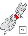
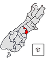
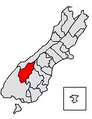
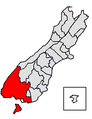
Locator Maps New Zealand[edit]
Maps about Districts and Cities edited, about Region not (6 new , 68 edited)
-
 Northland Region
 -
 Far North District
(Northland Region) -
 Kaipara District
(Northland Region) -
 Whangarei District
(Northland Region) -
 Auckland Council
 -
 Auckland Council
Unitary Authority -
 Rodney District (former)
(Auckland Region) -
 Waitakere City (former)
(Auckland Region) -
 North Shore City (former)
(Auckland Region) -
 Auckland City (former)
(Auckland Region) -
 Manukau City (former)
(Auckland Region) -
 Papakura District (former)
(Auckland Region) -
 Franklin District (former)
(Auckland Region) -
 Waikato Region
 -
 Waikato District
(Waikato Region) -
 Hamilton City
(Waikato Region) -
 Hauraki District
(Waikato Region) -
 Thames-Coromandel District
(Waikato Region) -
 Matamata-Piako District
(Waikato Region) -
 Otorohanga District
(Waikato Region) -
 Waipa District
(Waikato Region) -
 South Waikato District
(Waikato Region) -
 Waitomo District
(Waikato Region) -
 Taupo District
(Waikato Region) -
 Bay of Plenty region
 -
 Western Bay of Plenty District
(Bay of Plenty Region) -
 Tauranga City
(Bay of Plenty Region) -
 Rotorua District
(Bay of Plenty Region) -
 Whakatane District
(Bay of Plenty Region) -
 Kawerau District
(Bay of Plenty Region) -
 Opotiki District
(Bay of Plenty Region) -
 Gisborne Region
 -
 Gisborne District
Unitary Authority -
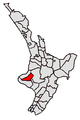
 Hawke's Bay Region
 -
 Wairoa District
(Hawke's Bay Region) -
 Hastings District
(Hawke's Bay Region) -
 Napier City
(Hawke's Bay Region) -
 Central Hawke's Bay District
(Hawke's Bay Region) -
 Taranaki Region
 -
 New Plymouth District
(Taranaki Region) -
 Stratford District
(Taranaki Region) -
 South Taranaki District
(Taranaki Region) -
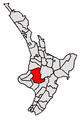
 Manawatu-Wanganui Region
 -
 Ruapehu District
(Manawatu-Wanganui Region) -
 Wanganui District
(Manawatu-Wanganui Region) -
 Rangitikei District
(Manawatu-Wanganui Region) -
 Manawatu District
(Manawatu-Wanganui Region) -
 Palmerston North City
(Manawatu-Wanganui Region) -
 Horowhenua District
(Manawatu-Wanganui Region) -
 Tararua District
(Manawatu-Wanganui Region) -
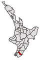
 Wellington Region
 -
 Kapiti Coast District
(Wellington Region) -
 Porirua City
(Wellington Region) -
 Wellington City
(Wellington Region) -
 Upper Hutt City
(Wellington Region) -
 Hutt City
(Wellington Region) -
 Masterton District
(Wellington Region) -
 Carterton District
(Wellington Region) -
 South Wairarapa District
(Wellington Region) -
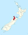
 Nelson Region
 -
 Nelson City
Unitary Authority -
 Tasman Region
 -
 Tasman District
Unitary Authority -
 Marlborough Region
 -
 Marlborough District
Unitary Authority -
 West Coast Region
 -
 Buller District
(West Coast Region) -
 Grey District
(West Coast Region) -
 Westland District
(West Coast Region) -
 Canterbury Region
 -
 Kaikoura District
(Canterbury Region) -
 Hurunui District
(Canterbury Region) -
 Selwyn District
(Canterbury Region) -
 Waimakariri District
(Canterbury Region) -
 Christchurch City
(Canterbury Region) -
 Ashburton District
(Canterbury Region) -
 Timaru District
(Canterbury Region) -
 Mackenzie District
(Canterbury Region) -
 Waimate District
(Canterbury Region) -
 Waitaki District
(Canterbury Region) -
 Otago Region
 -
 Queenstown-Lakes District
(Otago Region) -
 Central Otago District
(Otago Region) -
 Dunedin City
(Otago Region) -
 Clutha District
(Otago Region) -
 Southland Region
 -
 Southland District
(Southland Region) -
 Gore District
(Southland Region) -
 Invercargill City
(Southland Region) -
 Chatham Islands
(Special Territorial Authority)


Buildings and Constructions[edit]
List of pictures
| Pos | Image | Date | Title |
226 |
 |
17.09.2017 | Paeroa Memorial RSA (War Memorial), Main Road in Paeroa, Hauraki District, Waikato Region, North Island, New Zealand |
225 |
 |
12.09.2017 | Everybody's Theatre, Opunake, South Taranaki District, Taranaki Region, North Island, New Zealand |
224 |
.jpg) |
12.09.2017 | Opunake Hotel, Opunake, South Taranaki District, Taranaki Region, North Island, New Zealand (build 1915) |
223 |
27.08.2017 | Te Uri O Hina Marae (entrance), Pukepoto, Northland, North Island, New Zealand | |
222 |
 |
27.08.2017 | Te Uri O Hina Marae, Pukepoto, Northland, North Island, New Zealand |
221 |
.jpg) |
18.08.2017 | Moutere Inn, Upper Moutere (former Sarau), Tasman District, South Island, New Zealand (est. 1850) |
220 |
 |
18.08.2017 | St. Paul's Lutheran Community Church, Upper Moutere (former Sarau), Tasman District, South Island, New Zealand (Historic Place Category 2) |
219 |
,_Athenaeum.jpg) |
15.08.2017 | Athenaeum, Naseby, Central Otago District, Otago region, South Island, New Zealand, (build 1865) - Historic Places with the NZHPT Category 1 |
218 |
,_Strong%27s_Watchmaker_Shop.jpg) |
15.08.2017 | Strong's Watchmaker Shop, Naseby, Central Otago District, Otago Region, South Island, New Zealand, (build 1886) - Historic Places with the NZHPT Category 1 |
217 |
08.08.2017 | Millers Flat Bridge, Millers Flat, Central Otago District, Otago Region, South Island, New Zealand (build 1897–1899) | |
216 |
07.08.2017 | The Kauri Museum (front side) Matakohe, Kaipara District, Northland Region, North Island, New Zealand | |
215 |
14.06.2017 | Inangahua Hall, Inangahua Junction, Buller District, West Coast Region, North Island, New Zealand | |
214 |
13.06.2017 | Houhora Post Office (former), Houhora, Far North District, Northland Region, North Island, New Zealand | |
213 |
 |
13.06.2017 | Houhora Tavern, Houhora, Far North District, Northland Region, North Island, New Zealand |
212 |
.jpg) |
10.06.2017 | Post Office (former), Helensville, Auckland Councile, North Island, New Zealand |
211 |
06.05.2017 | Adelphi Hotel (after November 2016 earthquake), Kaikoura, Canterbury Region, South Island, New Zealand | |
210 |
26.03.2017 | Wai-O-Tapu Thermal Wonderland, Visitor Centre, Wai-O-Tapu geothermal area, Waikato Region, North Island, New Zealand | |
209 |
03.03.2017 | Solid Energy New Zealand, Coal plant, Stockton, Buller District, West Coast Region, South Island, New Zealand | |
208 |
02.03.2017 | Karamea Hotel (Waverley Street / Wharf Road), Buller District, West Coast Region, South Island, New Zealand | |
207 |
 |
02.03.2017 | Municipal Chambers, Westport, Buller District, West Coast Region, South Island, New Zealand (build 1940) |
206 |
01.03.2017 | Holcom, Cement factory, Westport, Buller District, West Coast Region, South Island, New Zealand | |
205 |
01.03.2017 | Municipal Chambers, Westport, Buller District, West Coast Region, South Island, New Zealand | |
204 |
24.02.2017 | Stone crusher at Hapuku River, Kaikoura District, Caterbury Region, South Island, New Zealand | |
203 |
 |
19.02.2017 | Hydroelectric Power Station Ohau A, Waitaki District, Canterbury Region, South Island, New Zealand |
202 |
19.02.2017 | Hydroelectric Power Station Ohau B, Waitaki District, Canterbury Region, South Island, New Zealand | |
201 |
19.02.2017 | Hydroelectric Power Station Ohau C, Waitaki District, Canterbury Region, South Island, New Zealand | |
200 |
 |
18.02.2017 | Irishman Creek, Post Box, „in the middle of nowhere“, Mackenzie District, Caterbury Region, South Island, New Zealand (Post Box is located at State Highway 8, 1 km north of Tekapo Canal) |
→ more images : have a look here
Cities, Towns and Suburbs[edit]
List of pictures
| Pos | Image | Date | Title |
51 |
28.10.2017 | Whitianga, Albert Street, Thames-Coromandel District, Waikato Region, North Island, New Zealand | |
50 |
20.10.2017 | Tirau, Main Road (SH 1), South Waikato Distrikt, Waikato Region, North Island, New Zealand | |
49 |
27.09.2017 | Main Road in Patea, South Taranaki District, Taranaki Region, North Island, New Zealand | |
48 |
12.09.2017 | Opunake, Main Road (SH 45), South Taranaki District, Taranaki Region, North Island, New Zealand | |
47 |
 |
09.09.2017 | Omarama, Chain Hills HWY (SH 83), Waitaki District, Canterbury Region, South Island, New Zealand |
46 |
18.08.2017 | Upper Moutere (former Sarau), center of village, Tasman District, South Island, New Zealand | |
45 |
18.08.2017 | Urenui (crossroad Nikorima Street / Ngakoti Street), New Plymouth District, Taranaki Region, North Island, New Zealand. (panoramic photo) | |
44 |
08.08.2017 | Junction to Millers Flat, New Zealand State Highway 8, Central Otago District, Otago Region, South Island, New Zealand | |
43 |
 |
10.06.2017 | Commercial Road, Helensville, Auckland Council, North Island, New Zealand |
42 |
19.05.2017 | Carters Road, New Zealand State Highway 1, Amberly, Canterbury, New Zealand, (view to the north) | |
41 |
06.03.2017 | Stoke Main Road in Stoke, suburb of Nelson, South Island, New Zealand | |
40 |
02.03.2017 | Karamea, crossroad Bridge Street, Buller District, West Coast region, South Island, New Zealand | |
39 |
02.03.2017 | Palmerston Street, Westport, Buller District, West Coast Region, South Island, New Zealand | |
38 |
 |
18.02.2017 | Fairlie, Main Street, Mackenzie District, Canterbury Region, South Island, New Zealand |
37 |
18.02.2017 | Lake Tekapo (Township, shopping line at SH 8), Mackenzie District, Canterbury Region, South Island, New Zealand | |
36 |
18.02.2017 | Lake Tekapo (Township), Mackenzie District, Canterbury Region, South Island, New Zealand (view from Mount John) | |
35 |
18.02.2017 | Methven, Ashburton District, Canterbury Region, South Island, New Zealand (crossroads, from left ro right: Methven Chertsey Road, Main Road (SH 77), Forest Drive, Methven HWY (SH 77)) | |
34 |
16.02.2017 | Aoraki/Mount Cook (village), often called Mount Cook Village, Canterbury, South Island, New Zealand | |
33 |
 |
13.02.2017 | Ardmore Street with view into Dungarvon Street, Wanaka, Queenstown-Lakes District, Otago Region, South Island, New Zealand |
32 |
13.02.2017 | Ardmore Street with view to the lake, Wanaka, Queenstown-Lakes District, Otago Region, South Island, New Zealand | |
31 |
13.02.2017 | Ardmore Street, Restaurants with seaview, Wanaka, Queenstown-Lakes District, Otago Region, South Island, New Zealand | |
30 |
 |
10.02.2017 | Mountainview Road, Culverden, Hurunui District, Canterbury Region, South Island, New Zealand (view to southwest |
29 |
08.02.2017 | Lyndon Street, Waiau, Hurunui District, Canterbury Region, South Island, New Zealand | |
28 |
 |
04.02.2017 | Market Street, Blenheim, Marlborough District, South Island, New Zealand |
27 |
01.02.2017 | Main Road, Katikati, Western Bay of Plenty District, North Island, New Zealand | |
26 |
29.01.2017 | Coromandel (main roads), Kapanga Road, Tiki Road, Wharf Road, Thames-Coromandel District, Waikato Region, North Island, New Zealand | |
25 |
 |
29.01.2017 | Coromandel, Kapanga Road, Thames-Coromandel District, Waikato Region, North Island, New Zealand |
24 |
15.01.2017 | Awanui Junction, SH 1 / SH 10, Northland, New Zealand | |
23 |
 |
11.01.2017 | Paihia, Williams Road, Northland, New Zealand |
22 |
 |
13.12.2015 | Korean traditional market at Jeongeup, Jeollabuk-do, South-Korea |
21 |
 |
13.12.2015 | Korean traditional market at Jeongeup, Jeollabuk-do, South-Korea |
20 |
 |
13.12.2015 | Korean traditional market at Jeongeup, Jeollabuk-do, South-Korea |
→ more images : have a look here
Landscapes[edit]
List of pictures
| Pos | Image | Date | Title |
52 |
16.04.2017 | Northland Peninsula, North Island, New Zealand (satellite image from NASA World Wind) | |
51 |
04.03.2017 | Stockton Opencast Mine, Buller District, West Coast Region, South Islan, New Zealand (view to the south from SH 67 from Karamea to Westport, west of Radiant Range) | |
49 |
23.02.2017 | Seaward Kaikoura Range, Kaikoura District, Canterbury Region, South Island, New Zealand, (view from Kaikoura Peninsual, Mount Sounders in center of the photo, in front left Mount Fyffe) | |
48 |
.jpg) |
23.02.2017 | Seaward Kaikoura Range, Kaikoura District, Canterbury Region, South Island, New Zealand, (view from Kaikoura Peninsula, with Mount Sounders) |
47 |
23.02.2017 | Seaward Kaikoura Range, Kaikoura District, Canterbury Region, South Island, New Zealand, (view from State Highway 1, north from Kaikoura township, Mount Sounders in center of the photo, in front left Mount Fyffe) | |
46 |
19.02.2017 | Mount John, Mackenzie District, Canterbury Region, South Island, New Zealand (aerial photo, view from north) | |
45 |
18.02.2017 | Irishman Creek, Post Box, „in the middle of nowhere“, Mackenzie District, Caterbury Region, South Island, New Zealand (Post Box is located at State Highway 8, 1 km north of Tekapo Canal) | |
44 |
.jpg) |
18.02.2017 | Lake Tekapo, Mackenzie District, Canterbury Region, South Island, New Zealand (aerial photo, view from northeast with Macaulay River and alluvial land from Godley River) |
43 |
.jpg) |
18.02.2017 | Lake Tekapo, Mackenzie District, Canterbury Region, South Island, New Zealand (aerial photo, view from south) |
42 |
18.02.2017 | Mt John University Observatory, Mount John at Lake Tekapo, Mackenzie District, Canterbury Region, South Island, New Zealand (view to the south) | |
41 |
 |
13.02.2017 | Wanaka East with mountain, Wanaka, Queenstown-Lakes District, Otago Region, South Island, New Zealand |
40 |
08.02.2017 | Waiau, Hurunui District, Canterbury Region, South Island, New Zealand | |
39 |
.jpg) |
31.01.2017 | The Pinnacles, Coromandel Range, Coromandel Peninsula, Thames-Coromandel District, Waikato Region, North Island, New Nealand, 759 m |
38 |
13.01.2017 | Bay of Islands, Northland, New Zealand, view from Waitangi Ground to the entrance, Tapeka Point, and Russell | |
37 |
 |
20.12.2014 | Mount Ruapehu and Rangipo Desert, North Island, New Zealand |
36 |
 |
20.12.2014 | Kakanui Mountains, Otago, New Zealand, close to Naseby and view from west side |
35 |
 |
20.12.2014 | Mitre Peak, Milford Sound, Southland, New Zealand (photo taken from southeast) |
34 |
17.04.2015 | Tussock grassland at State Highway 94 between Mossburn and The Key, South Island, New Zealand | |
33 |
 |
17.04.2015 | Tussock field at State Highway 94 between Mossburn and The Key, South Island, New Zealand |
32 |
17.04.2015 | Tussock on Farmland between Manapuri and Blackmount, South Island, New Zealand | |
31 |
 |
11.12.2014 | Salt Factory at Lake Grassmere, Marlborough Region, South Island, New Zealand |
30 |
11.12.2014 | Saline of Lake Grassmere, Marlborough Region, South Island, New Zealand | |
29 |
 |
11.12.2014 | Wharanui costal farmland (view from New Zealand State Highway 1 to north |
28 |
17.10.2014 | Rimutaka Range with Turakirae Head, Greater Wellington Region, south of North Island, New Zealand | |
27 |
 |
05.08.2014 | Mount Pohaturoa, Lake Atiamuri, Rotorua District, Waikato Region, North Island, New Zealand, 520 m |
26 |
01.07.2014 | Darßer Ort (natural landscape), Fischland-Darß-Zingst, Mecklenburg-Vorpommern, Germany | |
25 |
20.06.2014 | Port of Tauranga, Tauranga, Bay of Plenty, North Island, New Zealand | |
24 |
19.06.2014 | Martha Mine (gold mine), Waihi, Bay of Plenty, North Island, New Zealand | |
23 |
 |
17.06.2014 | Karangahake Gorge, Coromandel Peninsula, North Island, New Zealand |
22 |
 |
17.06.2014 | Karangahake Gorge, Coromandel Peninsula, North Island, New Zealand |
21 |
26.02.2010 | Te Mata Range, Havelock North, Hastings District, Hawke's Bay Region, New Zealand. | |
20 |
26.02.2010 | Te Mata (399 m), Havelock North, Hastings District, Hawke's Bay Region, New Zealand. |
→ more images : have a look here
Rivers, Lakes and Sea[edit]
List of pictures
| Pos | Image | Date | Title |
59 |
21.04.2017 | Porua Bay within Whangarei Harbour, Northland, North Island, New Zealand (view from west part of the bay via bay entrance to Whangarei Heads in background) | |
58 |
19.04.2017 | Parengarenga Harbour, Northland Region, North Island, New Zealand (view from New Zealand State Highway 1 near Waitiki Landing to the east) | |
57 |
.jpg) |
18.04.2017 | Manukau Harbour, North Island, New Zealand (satellite image from NASA) |
56 |
.jpg) |
15.04.2017 | Whangarei Harbour, Northland, North Island, New Zealand (satellite image) |
55 |
.jpg) |
26.03.2017 | Bursting bubble in mud vulcano in Wai-O-Tapu geothermal area, Waikato Region, North Island, New Zealand |
54 |
 |
26.03.2017 | Mud vulcano in Wai-O-Tapu geothermal area, Waikato Region, North Island, New Zealand |
53 |
 |
26.03.2017 | Three craters filled with coloured water in Wai-O-Tapu Thermal Wonderland, Wai-O-Tapu geothermal area, Waikato Region, North Island, New Zealand |
52 |
 |
18.03.2017 | Dawson Falls, Egmont National Park, Taranaki Region, North Island, New Zealand |
51 |
02.03.2017 | Karamea River, Karamea, Buller District, West Coast Region, South Island, New Zealand (view from bridge to southeast, state highway 67 close to town Karamea, in background to see the Stormy Ridge) | |
50 |
02.03.2017 | Karamea River, Karamea, Buller District, West Coast Region, South Island, New Zealand (view from bridge to west (seaside), state highway 67 close to town Karamea) | |
49 |
24.02.2017 | Hapuku River, Kaikoura District, Caterbury Region, South Island, New Zealand (view from State Highway 1 bridge 1451 to seaside) | |
48 |
24.02.2017 | Hapuku River, Kaikoura District, Caterbury Region, South Island, New Zealand (view from State Highway 1 bridge 1451 to Seaward Kaikoura Range) | |
47 |
19.02.2017 | Godley River, Mackenzie District, Canterbury Region, South Island, New Zealand (aerial photo, view from Lake Tekapo to north; Mount Errebus 2311 m, Sibbald Range in the middle of the photo) | |
46 |
.jpg) |
19.02.2017 | Lake Alexandrina, Mackenzie District, Canterbury Region, South Island, New Zealand (aerial photo, view from north) |
45 |
.jpg) |
19.02.2017 | Macaulay River, Mackenzie District, Canterbury Region, South Island, New Zealand, (aerial photo, Macaulay River with Two Thumb Range in background) |
44 |
19.02.2017 | Ohau River, Waitaki District, Canterbury Region, South Island, New Zealand (River close to Ohau A Power Station and some hundred meters before the river changed to Lake Ruataniwha) | |
43 |
17.02.2017 | Tekapo Canal, Mackenzie District, Canterbury Region, South Island, New Zealand (view from State Highway 8 to the east) | |
42 |
17.02.2017 | Tekapo Canal, Mackenzie District, Canterbury Region, South Island, New Zealand (view from State Highway 8 to the west) | |
41 |
_(Bridge_980_SH7).jpg) |
07.02.2017 | Hope River, North Canterbury, South Island, New Zealand (View from nearby bridge 980 State Highway 7 - 42/35/17/S - 172/27/11/E) |
40 |
_(view_from_SH_7).jpg) |
07.02.2017 | Hope River, North Canterbury, South Island, New Zealand (View from State Highway 7 - 42/35/30/S - 172/29/36/E) |
39 |
.jpg) |
07.02.2017 | Junction Waiau River and Hope River, North Canterbury Region, South Island, New Zealand (42/35/40.77/S - 172/33/38.70/E) |
38 |
06.02.2017 | Waiau River, Canterbury Region, New Zealand, (view to the West from bridge near by the town Waiau) | |
37 |
.jpg) |
05.02.2017 | Matakitaki River, Tasman Region, South Island, New Zealand (view to north from bridge 2440 SH 6) |
36 |
.jpg) |
05.02.2017 | Matakitaki River, Tasman Region, South Island, New Zealand (view to south from bridge 2440 SH 6) |
35 |
 |
31.01.2017 | Kauaeranga River, Coromandel Peninsula, Thames-Coromandel District, Waikato Region, North Island, New Zealand |
34 |
 |
22.01.2017 | Orere River, Auckland Council (southeast), North Island, New Zealand |
33 |
 |
15.01.2017 | Awanui River, Awanui, Northland, New Zealand, view from SH1 bridge |
32 |
 |
12.01.2017 | Kawakawa River, Northland, New Zealand |
31 |
 |
10.01.2017 | Hatea River, Whangarei, Nothland, New Zealand |
30 |
.jpg) |
15.06.2016 | Satellite photo of Lake Rotorua, North Island, New Zealand |
→ more images : have a look here
Miscellaneous[edit]
List of pictures
| Pos | Image | Date | Title |
36 |
06.05.2017 | Damaged railway track by November 2016 earthquake, north of Kaikoura town, Kaikoura District, Canterbury Region, South Island, New Zealand | |
35 |
 |
30.01.2017 | Firth of Thames, mussel farm at Matingerahi at the westcoast of Firth of Thames, North Island, New Zealand |
34 |
30.01.2017 | Firth of Thames, Seabird at the beach of Thames, Thames-Coromandel District, Waikato region, North Island, New Zealand | |
33 |
 |
25.11.2016 | Yellow Eggplant, Wintergarden, Auckland Domain, Auckland, New Zealand |
32 |
 |
11.10.2015 | National Cash Register, Shantytown Heritage Park, West Coast, South Island, New Zealand |
31 |
 |
11.10.2015 | Mergenthaler Linotype typesetting machine, Shantytown Heritage Park, West Coast, South Island, New Zealand |
30 |
 |
10.10.2015 | Replica of the Greymouth Masonic Lodge room, Shantytown Historical Park, West Coast, South Island, New Zealand |
29 |
 |
10.10.2015 | Tea room with interior decoration, Shantytown Historical Park, West Coast, South Island, New Zealand |
28 |
 |
10.10.2015 | Saloon of Golden Nugget Hotel, Shantytown Historical Park, West Coast, South Island, New Zealand |
27 |
 |
10.10.2015 | Locomotive NZR L 508 in Shantytown Heritage Park, West Coast, South Island, New Zealand, built 1877 by Avonside Engine Company, Bristol, England |
26 |
 |
23.04.2015 | Sogo ( 소고 ), small Korean hand-held drum
|
25 |
 |
05.08.2014 | Lake Atiamuri Power Station, Rotorua District, Waikato Region, North Island, New Zealand, build 1953–1958 |
24 |
 |
03.07.2014 | Tokaanu Power Station at Lake Taupo, Waikato, North Island, New Zealand, was built from 1966 to 1973 |
23 |
 |
14.06.2014 | John Ballance, Gravestone, Whanganui, New Zealand |
22 |
18.12.2013 | Dunedin Midwinter Carnival 2008, Dunedin, New Zealand. The event is celebrated each year on the 21st of June, the longest night of the year. | |
21 |
 |
27.12.2013 | Santa Claus Parade, Dunedin, New Zealand (2007) |
20 |
 |
23.07.2013 | Pipelines of a geothermal power station north of Taupo, New Zealand |
19 |
 |
15.05.2013 | Graves of May 18th National Cemetery, Gwangju, Jeollanam-do, South Korea. |
18 |
.jpg) |
13.01.2013 | Jing, traditional Korean gong. |
17 |
 |
10.01.2013 | Jindo-Buk, Korean traditional drum. |
16 |
 |
08.01.2013 | Sori-Buk, Korean drum for Pansori performance. |
15 |
 |
06.07.2011 | Moriori Dendroglyph, Chatham Islands, New Zealand, around 1900 (cut). |
14 |
06.07.2011 | Moriori Dendroglyph, Chatham Islands, New Zealand, around 1900. | |
13 |
 |
24.07.2010 | Maori sculpture, Toi's pa, Whakatane, Bay of Plenty Region, New Zealand. |
12 |
 |
29.04.2010 | Grave of William Hobson (1793–1842), first governor in New Zealand. Symonds Street Cemetery in Auckland. |
11 |
28.01.2010 | Edgecumbe Earthquake Memorial, Edgecumbe, Bay of Plenty, New Zealand. | |
10 |
 |
25.01.2010 | Wairaka sculpture, Whakatane, Mouth of Whakatane River, Bay of Plenty, New Zealand. |
→ more images : have a look here