Bokmål: Jan Mayen er en 373 km² stor arktisk øy. Øya er delvis tildekket av en isbre. Øya ligger på 70,97° N 8,6° vest. Her ligger også Norges eneste aktive vulkan, Beerenberg, som med sine 2277 meter også er et av Norges høyeste fjell. Fiskerisonen ved Jan Mayen er 293 049 km². I 1980 ble den økonomiske sonen utvidet til 200 nautiske mil rundt øya, til protester fra naboøyene Island og Grønland. Jan Mayen er en del av Kongeriket Norge, er ikke et biland og omfattes ikke av Svalbardtraktaten.
Nynorsk: Jan Mayen er ei 373 km² stor arktisk øy og ein del av Noreg. Øya er delvis dekt av ein isbre. Øya ligg på 71°N, 8°W. Her ligg òg Noregs einaste aktive vulkan, Beerenberg, som med sine 2277 meter over havet er eit av Noregs høgste fjell.
Jan Mayen, a constituent part of the Kingdom of Norway, is a 55-km-long (southwest-northeast) and 373-km² island in the Arctic Ocean, partly covered by glaciers. It has two parts: the larger Nord-Jan and the smaller Sør-Jan, both linked by an isthmus 2.5 km wide. It lies 600 km north of ► Iceland, 500 km east of ► Greenland, and 1,000 km west of the Norwegian mainland at 70.97° N 8.6° W.
This section holds a short summary of the history of the area of present-day Jan Mayen, illustrated with maps, including historical maps of former countries and empires that included present-day Jan Mayen.
The Island of Jan Mayen, discovered by Henry Hudson in 1607, is annexed by Norway in 1929. Jan Mayen is administered as part of mainland Norway and has no self-government. No maps are available.
Jan Mayen, ble oppdaget av Henry Hudson 1607, og le annektert av Norge 1929. Jan Mayen administreres som en del av fastlands-Norge og har ingen selvstyre. Ingen kart er tilgjengelig.
Old maps
This section holds copies of original general maps more than 70 years old.
Jacobus Robijn (17th century)
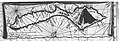
17th century nautical chart
Johannes Jansson 1650
Joan Blaeu map of Jan Mayen (ca. 1670)
Vincenzo Coronelli (1692)
Cornelis Gijsbertsz Zorgdrager (before 1720)
Nicolas Bellin (ca. 1760)
Nicolas Bellin, colored (ca. 1760)
William Scoresby (1820)
Carl Vogt (1863)
AL (1865)
Carl Fredrik Wille and Henrik Mohn after Cornelis Gijsbertsz Zorgdrager and William Scoresby (1878)
Carl Fredrik Wille, Henrik Mohn (1882)
Josef Chavanne (1884)
Emil von Wohlgemuth (1884)
Royal Geographical Society (1939)
Satellite maps
Satellite image of Jan Mayen
Notes and references
General remarks:
The WIKIMEDIA COMMONS Atlas of the World is an organized and commented collection of geographical, political and historical maps available at Wikimedia Commons. The main page is therefore the portal to maps and cartography on Wikimedia. That page contains links to entries by country, continent and by topic as well as general notes and references.
Every entry has an introduction section in English. If other languages are native and/or official in an entity, introductions in other languages are added in separate sections. The text of the introduction(s) is based on the content of the Wikipedia encyclopedia. For sources of the introduction see therefore the Wikipedia entries linked to. The same goes for the texts in the history sections.
Historical maps are included in the continent, country and dependency entries.
The status of various entities is disputed. See the content for the entities concerned.
The maps of former countries that are more or less continued by a present-day country or had a territory included in only one or two countries are included in the atlas of the present-day country. For example the Ottoman Empire can be found in the Atlas of Turkey.


 Jacobus Robijn (17th century)
 17th century nautical chart
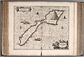 Johannes Jansson 1650
 Joan Blaeu map of Jan Mayen (ca. 1670)
 Vincenzo Coronelli (1692)
 Cornelis Gijsbertsz Zorgdrager (before 1720)
 Nicolas Bellin (ca. 1760)
 Nicolas Bellin, colored (ca. 1760)
 William Scoresby (1820)
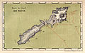 Carl Vogt (1863)
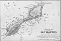 AL (1865)
 Carl Fredrik Wille and Henrik Mohn
 Carl Fredrik Wille, Henrik Mohn (1882)
 Josef Chavanne (1884)
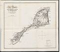 Emil von Wohlgemuth (1884)
 Royal Geographical Society (1939)


_MAP_OF_JAN_MAYEN.jpg)


