Category:1680s maps of the Netherlands
Jump to navigation
Jump to search
Countries of Europe: Armenia‡ · Austria · Azerbaijan‡ · Belgium · Bosnia and Herzegovina · Bulgaria · Croatia · Cyprus‡ · Denmark · France‡ · Georgia‡ · Germany · Greece · Hungary · Republic of Ireland · Italy · Lithuania · Montenegro · Netherlands‡ · Norway · Poland · Portugal‡ · Romania · Russia‡ · Serbia · Slovakia · Slovenia · Spain‡ · Sweden · Switzerland · Turkey‡ · Ukraine
‡: partly located in Europe
‡: partly located in Europe
Subcategories
This category has the following 2 subcategories, out of 2 total.
Media in category "1680s maps of the Netherlands"
The following 22 files are in this category, out of 22 total.
-
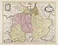
 Ducatus Geldriae Tetrachia Arnhemiensis sive Velavia (8345415435).jpg 800 × 669; 170 KB
-
 GMG709188mapa0092 Belgium Foederatum de Wit.jpg 7,897 × 6,522; 6.89 MB
-

-
 Tetrachia Ducatus Geldriae Neomagensis (8345415491).jpg 800 × 670; 181 KB
-
 Tetrachia ducatus Geldriae Ruremondana sive Hispanica (8346435288).jpg 800 × 679; 186 KB
-
 Holland or the United Provinces (NYPL b14428893-1503422).jpg 6,299 × 5,248; 6.76 MB
-
 Ducatus Geldria et Zutphania Comitatus (Nicolaas Visscher, 1682).jpg 5,500 × 4,562; 5.52 MB
-
 Heerlijkheid Bergambacht en Ammerstol.jpg 3,041 × 3,062; 5.22 MB
-
 1687 Provinces Valk.jpg 1,788 × 1,500; 4.03 MB
-

-
 Provinces Unies des Pays-Bas avec leurs Acquisitions... - Sr. Sanson - btv1b531195536.jpg 10,848 × 7,428; 12.31 MB
-

-

-
 Atlas Van der Hagen-KW1049B11 059-BRABANTIAE PARS-SEPTENTRIONALIS ....jpeg 5,500 × 4,687; 4.7 MB
-

-

-
 Belgium Foederatum 1680.jpg 5,500 × 4,626; 5.27 MB
-
 Comitatus Hollandiae Tabula.jpg 6,831 × 5,694; 15.58 MB
-
 Ditio Trans-Isulana auctore Bartholdo Wicheringe. - CBT 6612298.jpg 5,669 × 4,416; 7.6 MB
-
 Heerlijkheid Friesland 1680.jpg 5,500 × 4,701; 6 MB
-
 Karte der Grenze zwischen den Niederlanden und Ostfriesland.jpg 3,000 × 1,685; 739 KB
-

.jpg)

.jpg)
.jpg)
.jpg)
.jpg)
.jpg)


.jpg)