Category:1690 maps
Jump to navigation
Jump to search
| ← · 1690 · 1691 · 1692 · 1693 · 1694 · 1695 · 1696 · 1697 · 1698 · 1699 · → |
Deutsch: Karten mit Bezug zum Jahr 1690
English: Maps related to the year 1690
Español: Mapas relativos al año 1690
Français : Cartes concernant l’an 1690
Русский: Карты 1690 года
Subcategories
This category has the following 6 subcategories, out of 6 total.
Media in category "1690 maps"
The following 55 files are in this category, out of 55 total.
-
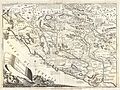 1690 Coronelli Map of Montenegro - Geographicus - Montenegro-coronelli-1690.jpg 5,000 × 3,742; 5.28 MB
-

-

-
-

-

-

-
 Americae nova discriptio (5384787285).jpg 2,000 × 1,608; 2.93 MB
-

-

-
 Atlas Van der Hagen-KW1049B13 038-XENSI. IMPERII SINARVM PROVINCIA TERTIA.jpeg 5,500 × 4,608; 3.66 MB
-
 Atlas Van der Hagen-KW1049B13 039-XANTVNG SINARVM IMPERII PROVICIA QUARTA.jpeg 5,500 × 4,523; 3.67 MB
-
 Atlas Van der Hagen-KW1049B13 040-HONAN. IMPERII SINARVM PROVINCIA QVINTA.jpeg 5,500 × 4,624; 3.07 MB
-

-

-
 Capitainerie Brouage Tassin 16920.jpg 4,037 × 2,783; 9.72 MB
-
 Carel Allard, Totius Fluminis Rheni Novissima Descriptio (FL155340116 3014979).jpg 14,703 × 12,655; 219.08 MB
-

-

-

-
 El Reino de Navarra.png 485 × 673; 630 KB
-
 Frederik de Wit, Nova Persiæ Armeniæ Natoliæ et Arabiæ descriptio (FL35868182 2714639).jpg 14,069 × 12,031; 222.43 MB
-
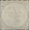
 Frederik de Wit, Poli Arctici, et circumiacentium terrarum descriptio novissima (FL37810528 3146801).jpg 15,375 × 13,042; 260.37 MB
-
 Gaspar Bouttats (approximately 1640-), Newhevsel (FL39696752 3699750).jpg 6,827 × 4,054; 42.02 MB
-
 Gaspar Bouttats (approximately 1640-), Nitria (FL167448326 2369916).jpg 7,035 × 4,320; 32.43 MB
-
 Gaspar Bouttats (approximately 1640-), Petrinia (FL39696757 3700058).jpg 3,607 × 3,961; 16.54 MB
-
 Gaspar Bouttats (approximately 1640-), Sisect (FL39696762 3700061).jpg 3,402 × 3,944; 16.05 MB
-

-
 Isole Antili, la Cuba e la Spagnuola LOC 95684858.jpg 5,484 × 3,504; 3.25 MB
-
 Isole Antili, la Cuba e la Spagnuola LOC 95684858.tif 5,484 × 3,504; 54.98 MB
-

-
 Kaart van de Veluwe, de Betuwe en de graafschap Zutphen in het hertogdom Gelre ECAL 0098-413.jpg 5,863 × 7,634; 11.21 MB
-
 L'Asie selon les mémoires les (...)Coronelli Vincenzo btv1b530890106.jpg 1,152 × 868; 485 KB
-
 Mea du japon1704.jpg 2,328 × 1,701; 1.78 MB
-
 Međimurje (Croatia) - stari zemljovid iz 1690.jpg 2,592 × 1,944; 1.35 MB
-
 Mitileme - Peeters Jacob - 1690.jpg 1,500 × 1,064; 927 KB
-
 Nicolaes Visscher II, Peloponnesus hodie Morea (FL35069477 2528717).jpg 14,395 × 11,759; 222.27 MB
-
 Novissima et accuratissima totius Americae descriptio (4072628808).jpg 2,000 × 1,716; 3.4 MB
-
 Orbis terrarum nova et accuratissima tabula LOC 2006627252.jpg 6,897 × 5,824; 7.78 MB
-
 Orbis terrarum nova et accuratissima tabula LOC 2006627252.tif 6,897 × 5,824; 114.92 MB
-
 Palestina siue Terræ Sanctæ descriptio (FL37116730 3894099).jpg 11,894 × 7,257; 111.87 MB
-
 Parte della Schiavonia la Contea di Cillea, e Windisch Mark, abitate da popoli Slauini, o Slaui 1690.jpg 14,168 × 10,602; 19.63 MB
-

-

-

-
 Plan de Mastrich - btv1b84457071.jpg 10,054 × 7,764; 9.71 MB
-

-

-
-

-

-
 Vincenzo Coronelli, Asia 01 (FL27959705 2487180).jpg 12,112 × 16,960; 294.93 MB
-
 Vincenzo Coronelli, Asia 02 (FL27959709 2487180).jpg 12,133 × 17,020; 271.96 MB
-
 Vincenzo Coronelli, Canale di Constantinopoli Già detto Bosforo Tracio (FL35866752 2632075).jpg 11,489 × 7,982; 135.9 MB
-
 Vkraina-Cosaques-Okraina small.png 357 × 284; 242 KB

_-_Geographicus_-_ScotiaParteMeridionale-coronelli-1690.jpg)

.jpg)
.jpg)
.jpg)


.jpg)
.jpg)

.jpg)
.jpg)
.jpg)

.jpg)
.jpg)
,_Newhevsel_(FL39696752_3699750).jpg)
,_Nitria_(FL167448326_2369916).jpg)
,_Petrinia_(FL39696757_3700058).jpg)
,_Sisect_(FL39696762_3700061).jpg)
.jpg)


Coronelli_Vincenzo_btv1b530890106.jpg)

_-_stari_zemljovid_iz_1690.jpg)

.jpg)
.jpg)

.jpg)

.jpg)
.jpg)
.jpg)

.jpg)
.jpg)
.jpg)
.jpg)
