File:A new mapp of America - devided according to the best and latest observations and discoveries, wherein are described by their proper names, the seaverall countries that belonge to ye English. NYPL434541.tiff
Jump to navigation
Jump to search

Size of this PNG preview of this TIF file: 641 × 600 pixels. Other resolutions: 256 × 240 pixels | 513 × 480 pixels | 821 × 768 pixels | 1,094 × 1,024 pixels | 2,188 × 2,048 pixels | 5,531 × 5,176 pixels.
Original file (5,531 × 5,176 pixels, file size: 68.46 MB, MIME type: image/tiff)
Captions
Captions
Add a one-line explanation of what this file represents
Summary[edit]
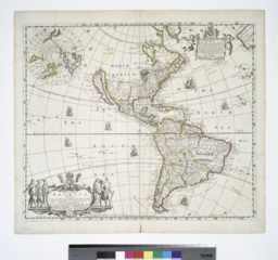
| Description | A new mapp of America : devided according to the best and latest observations and discoveries, wherein are described by their proper names, the seaverall countries that belonge to ye English, which are wholly left out in all French and Dutch maps, viz. New Scotland, Long Island, N. York, N. Jarsey, Mary Land, Pensilvania, Carrolina, et[c]. / Philip Lea excudit ; James Moxon sculp. | |||||||||||||||||||||||
| Notes | Includes inset of the Arctic, decorative cartouche, note, ill., and dedication by Philip Lea. Note 2.) Lawrence H. Slaughter Collection ; 765. Note 3.) Prime meridian: Teneriff. Note 4.) Relief shown pictorially. Note 5.) National Endowment for the Humanities Grant for Access to Early Maps of the Middle Atlantic Seaboard. | |||||||||||||||||||||||
| Standard reference | Phillips. Maps of America, p. 106; Tooley, R.V. Mapping of America, p. 124, [no.] 54 | |||||||||||||||||||||||
| Physical description | 1 map : hand col. ; 47 x 55 cm. | |||||||||||||||||||||||
| Catalog Call Number | Map Div. 97-6432 [LHS 765] | |||||||||||||||||||||||
| Date | ||||||||||||||||||||||||
| Source |
http://digitalgallery.nypl.org/nypldigital/dgkeysearchdetail.cfm?imageID=434541
|
|||||||||||||||||||||||
| Author | Lea, Philip, fl. 1683-1700 -- Publisher ;Moxon, J. (James) -- EngraverOverton, John, 1640-1708? -- Publisher | |||||||||||||||||||||||
| Permission (Reusing this file) |
From The Lionel Pincus & Princess Firyal Map Division. Released on a CC0 license.[1] | |||||||||||||||||||||||
| Digital ID | 434541 | |||||||||||||||||||||||
| Location | Stephen A. Schwarzman Building / The Lionel Pincus and Princess Firyal Map Division | |||||||||||||||||||||||
| NYPL digital item published | 2-3-2004; updated 3-25-2011 | |||||||||||||||||||||||

Licensing[edit]
| This file is made available under the Creative Commons CC0 1.0 Universal Public Domain Dedication. | |
| The person who associated a work with this deed has dedicated the work to the public domain by waiving all of their rights to the work worldwide under copyright law, including all related and neighboring rights, to the extent allowed by law. You can copy, modify, distribute and perform the work, even for commercial purposes, all without asking permission.
|
The making of this file was supported by Wikimedia UK.
To see other files made with the support of Wikimedia UK, please see the category Supported by Wikimedia UK.
|
File history
Click on a date/time to view the file as it appeared at that time.
| Date/Time | Thumbnail | Dimensions | User | Comment | |
|---|---|---|---|---|---|
| current | 20:23, 3 April 2014 |  | 5,531 × 5,176 (68.46 MB) | Finavon (talk | contribs) | rotated |
| 19:19, 2 April 2014 |  | 5,176 × 5,531 (81.91 MB) | Fæ (talk | contribs) | =={{int:filedesc}}== {{NYPL_map |creator(s) = Lea, Philip, fl. 1683-1700 -- Publisher ;Moxon, J. (James) -- Engraver |standard_reference = Phillips. Maps of America, p. 106; Tooley, R.V. Mapping of America, p. 124, [no.] 54 |record_id = 253161 |catalog... |
You cannot overwrite this file.
File usage on Commons
The following 2 pages use this file: