Category:1780s maps of North Rhine-Westphalia
Jump to navigation
Jump to search
Federal states of Germany:
Subcategories
This category has only the following subcategory.
Media in category "1780s maps of North Rhine-Westphalia"
The following 4 files are in this category, out of 4 total.
-

-
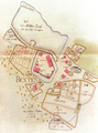 Amtsmeierhof zu Bexten (1786).png 889 × 1,195; 2.14 MB
-
 Krefeld um 1786 - Daniel Braches.jpg 2,748 × 3,961; 2.35 MB
-
 Limburger Mark, 1782 (Detail). Landesarchiv NRW Abteilung Westfalen, Nr. 6327.png 1,284 × 1,186; 3.02 MB
.jpg)
.png)

._Landesarchiv_NRW_Abteilung_Westfalen,_Nr._6327.png)