Category:1848 maps of Europe
Jump to navigation
Jump to search
Temperate regions: North America · South America · Africa · Europe · Asia · Oceania – Polar regions: – Other regions:
| ← 1840 1841 1842 1843 1844 1845 1846 1847 1848 1849 → |
English: 1848 maps of Europe
Español: Mapas de Europa en 1848
Suomi: Euroopan kartat vuodelta 1848
Română: Hărți ale Europei din 1848
Subcategories
This category has the following 10 subcategories, out of 10 total.
.
A
- 1848 maps of Austria (2 F)
F
- 1848 maps of France (8 F)
G
N
- 1848 maps of the Netherlands (1 F)
- 1848 maps of Norway (6 F)
P
- 1848 maps of Poland (1 F)
S
- 1848 maps of Spain (8 F)
Media in category "1848 maps of Europe"
The following 12 files are in this category, out of 12 total.
-
 Bilderrevolution0444.jpg 2,797 × 3,581; 2.38 MB
-
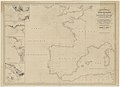
 Carte de géographie historique - par J. Belin de Launay... - btv1b530881910.jpg 7,048 × 5,552; 4.42 MB
-
-

-
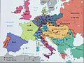
 Europe 1848 map de.png 2,284 × 1,503; 1.22 MB
-
 Europe 1848 map ru.png 2,284 × 1,503; 1.23 MB
-

-
 Map1848.jpg 720 × 541; 71 KB
-
 Politische Charte von Europa, 1848 Moldau.png 375 × 324; 114 KB
-
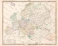
 Politische Charte von Europa, 1848.jpg 4,340 × 3,153; 3.81 MB
-
 Übersichtskarte der europäischen Länder Platt 1848.pdf 2,995 × 2,377; 748 KB
-
 Übersichtskarte der Hoch- Flach u Tiefländer in Europa Platt 1848.pdf 2,995 × 2,377; 621 KB


_-_par_Robiquet_-_btv1b532217492.jpg)
.jpg)


