Category:1843 maps of Europe
Jump to navigation
Jump to search
Temperate regions: North America · South America · Africa · Europe · Asia · – Polar regions: – Other regions:
English: 1843 maps of Europe
Español: Mapas de Europa en 1843
Suomi: Euroopan kartat vuodelta 1843
Română: Hărți ale Europei din 1843
Subcategories
This category has the following 8 subcategories, out of 8 total.
.
F
G
I
- 1843 maps of Italy (6 F)
N
- 1843 maps of Norway (10 F)
S
- 1843 maps of Spain (4 F)
T
- 1843 maps of Turkey (empty)
Media in category "1843 maps of Europe"
The following 10 files are in this category, out of 10 total.
-

-
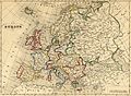 Carte Europe 1843.jpg 3,369 × 2,475; 6.04 MB
-
 Carte générale d'Europe dressée - par Charle... - btv1b53093054w.jpg 9,432 × 6,728; 10.83 MB
-
 Europe pittoresque - btv1b532239660.jpg 11,284 × 8,320; 15.92 MB
-
 Europe, large ethnographic, Johnston, 1848.jpg 753 × 622; 118 KB
-
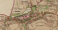
 Porvoo 1843.jpg 1,200 × 901; 136 KB
-
 Karta öfver landswägarne uti Sverige och Norige LOC 2015591081.jpg 7,745 × 11,054; 14.64 MB
-
 Karta öfver landswägarne uti Sverige och Norige LOC 2015591081.tif 7,745 × 11,054; 244.94 MB
-
 Ustek COSK 1843.jpg 4,000 × 2,201; 3.51 MB
-
 Ustek RSK.jpg 4,000 × 2,097; 4.6 MB
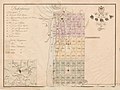
,_Carte_de_l%27indigence_dans_la_ville_de_Bruxelles_-_M%C3%A9moire_de_M._Quetelet_sur_le_recensement_de_1842_(Brussels,_KBR).png)


