Category:1887 maps of Pennsylvania
Jump to navigation
Jump to search
States of the United States: California · Connecticut · Florida · Georgia · Iowa · Kansas · Louisiana · Maine · Massachusetts · Michigan · Minnesota · Mississippi · Missouri · New Hampshire · New Jersey · New York · North Carolina · Ohio · Pennsylvania · South Dakota · Tennessee · Texas · Utah · Vermont · Virginia · Washington · Wisconsin · Wyoming
| ← 1881 1882 1883 1884 1885 1886 1887 1888 1889 → |
Subcategories
This category has the following 18 subcategories, out of 18 total.
C
P
- 1887 maps of Philadelphia (2 F)
Media in category "1887 maps of Pennsylvania"
The following 9 files are in this category, out of 9 total.
-
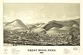 Great Bend, Penn. 1887. LOC 75694980.jpg 6,568 × 4,304; 5.46 MB
-
 Great Bend, Penn. 1887. LOC 75694980.tif 6,568 × 4,304; 80.88 MB
-
 Hallstead, Penn. 1887. LOC 75694984.jpg 6,040 × 4,480; 4.61 MB
-
 Hallstead, Penn. 1887. LOC 75694984.tif 6,040 × 4,480; 77.42 MB
-
 Lancaster, with its rail road connections - 1887. LOC 2004627700.jpg 5,560 × 4,876; 2.64 MB
-
 View of Ephrata, Pennsylvania. LOC 77691640.jpg 10,048 × 6,352; 14.66 MB
-
 View of Ephrata, Pennsylvania. LOC 77691640.tif 10,048 × 6,352; 182.6 MB
-
 View of Lititz and Warwick, Lancaster County, Pa. - 1887 LOC 94681740.jpg 11,098 × 7,935; 14.65 MB
-
 View of Lititz and Warwick, Lancaster County, Pa. - 1887 LOC 94681740.tif 11,098 × 7,935; 251.95 MB


