Category:1900 maps of Ohio
Jump to navigation
Jump to search
States of the United States: California · Connecticut · Florida · Georgia · Idaho · Illinois · Indiana · Iowa · Kansas · Massachusetts · Michigan · Minnesota · Missouri · Nebraska · New Jersey · New York · North Carolina · North Dakota · Ohio · Oklahoma · Pennsylvania · Rhode Island · South Carolina · South Dakota · Tennessee · Texas · Utah · Vermont · Virginia · Washington · West Virginia · Wisconsin · Wyoming – Washington, D.C.
| ← 1900 1901 1902 1904 1905 1906 1907 1908 1909 → |
Media in category "1900 maps of Ohio"
The following 4 files are in this category, out of 4 total.
-
 OH Toledo 520140 1900 62500.jpg 2,482 × 3,051; 1.45 MB
-
 Panoramic view, city of Cincinnati, U.S.A. 1900. LOC 75694914 (3600px).jpg 3,600 × 2,111; 3.97 MB
-
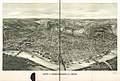 Panoramic view, city of Cincinnati, U.S.A. 1900. LOC 75694914.jpg 14,320 × 9,664; 26.61 MB
-

.jpg)
