Category:Alsager
Jump to navigation
Jump to search
town and civil parish in Cheshire East, England   | |||||
| Upload media | |||||
| Instance of | |||||
|---|---|---|---|---|---|
| Location | Cheshire East, Cheshire, North West England, England | ||||
| Population |
| ||||
| Different from | |||||
| Said to be the same as | Alsager (Wikimedia duplicated page, civil parish) | ||||
 | |||||
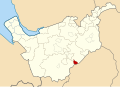
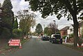
English: Alsager is a town and civil parish in the unitary authority of Cheshire East and the ceremonial county of Cheshire, England, to the north-west of the city of Stoke-on-Trent, and east of the railway town of Crewe. The town has a population of 12,578,
Nederlands: Alsager is een plaats in het bestuurlijke gebied Congleton, in het Engelse graafschap Cheshire. De plaats telt 12.578 inwoners.
Polski: Alsager - miasto w Wielkiej Brytanii, w Anglii, w regionie North West England, w hrabstwie Cheshire. W 2001r. miasto to zamieszkiwało 12 578 osób.
Română: Alsager este un oraş în comitatul Cheshire, regiunea North West England, Anglia. Oraşul se află în districtul Congleton.
Simple English: Alsager is a Town in Cheshire, United Kingdom. It is in the Borough of Congleton.The town has a population of 12,578,
Subcategories
This category has the following 8 subcategories, out of 8 total.
A
- Alsager Town F.C. (4 F)
B
- Borrow Pit Meadows (15 F)
L
- Lawton Brook (3 F)
M
- Merelake Way (19 F)
P
S
- Streets in Alsager (22 F)
W
Media in category "Alsager"
The following 140 files are in this category, out of 140 total.
-
 Agricultural building near Alsager - geograph.org.uk - 4199642.jpg 898 × 480; 36 KB
-
 Agricultural land on the fringe of Alsager - geograph.org.uk - 4199655.jpg 1,024 × 768; 64 KB
-
 Alsager Golf Course - geograph.org.uk - 4970000.jpg 4,896 × 3,672; 4.42 MB
-
 Alsager Golf Course, bunker and green - geograph.org.uk - 4971383.jpg 4,896 × 3,672; 4.2 MB
-
 Alsager Mere - geograph.org.uk - 4967723.jpg 4,896 × 3,672; 2.41 MB
-
 Alsager Mere - geograph.org.uk - 4967816.jpg 4,896 × 3,672; 2.51 MB
-
 Alsager Mere - geograph.org.uk - 4967846.jpg 4,896 × 3,672; 4.19 MB
-
 Alsager Sewage Farm - geograph.org.uk - 4231298.jpg 1,600 × 1,200; 595 KB
-
 Alsager Sprink - geograph.org.uk - 2760127.jpg 2,304 × 1,728; 1.26 MB
-
 Alsager town boundary sign, Sandbach Road North.jpg 3,872 × 2,592; 10.93 MB
-
 Alsager Town Centre - geograph.org.uk - 25493.jpg 640 × 480; 97 KB
-
 Alsager Urban District, Cheshire (1970).svg 1,410 × 1,018; 385 KB
-
 Alsager, adult fitness facility - geograph.org.uk - 4491549.jpg 3,264 × 2,448; 2.11 MB
-
 Alsager, building site next to Mere - geograph.org.uk - 4967808.jpg 4,896 × 3,672; 2.69 MB
-
 Alsager, children's play area off Fairview car park - geograph.org.uk - 4491539.jpg 3,264 × 2,448; 2.04 MB
-
 Alsager, community gardens - geograph.org.uk - 3274883.jpg 1,024 × 766; 198 KB
-
 Alsager, Coronation Gardens - geograph.org.uk - 4967717.jpg 4,896 × 3,672; 4.25 MB
-
 Alsager, entrance to field off Fanny's Croft - geograph.org.uk - 4494299.jpg 3,008 × 2,000; 1.68 MB
-
 Alsager, Fairview car park - geograph.org.uk - 4491529.jpg 3,264 × 2,448; 2.13 MB
-
 Alsager, Fanny's Croft - geograph.org.uk - 4494264.jpg 3,008 × 2,000; 1.55 MB
-
 Alsager, field off Fanny's Croft (1) - geograph.org.uk - 4494275.jpg 3,008 × 2,000; 1.35 MB
-
 Alsager, field off Fanny's Croft (2) - geograph.org.uk - 4494283.jpg 3,008 × 2,000; 1.26 MB
-
 Alsager, field off Fanny's Croft (3) - geograph.org.uk - 4494291.jpg 3,008 × 2,000; 1.06 MB
-
 Alsager, field off Fanny's Croft (4) - geograph.org.uk - 4494293.jpg 3,008 × 2,000; 1.16 MB
-
 Alsager, flower beds in Milton Park - geograph.org.uk - 4491931.jpg 3,008 × 2,000; 1.68 MB
-
 Alsager, footpath off Hassall Road - geograph.org.uk - 4493722.jpg 3,008 × 2,000; 1.41 MB
-
 Alsager, housing construction off Hassall Road - geograph.org.uk - 4493696.jpg 3,008 × 2,000; 1.07 MB
-
 Alsager, junction of Church Road and Lodge Road - geograph.org.uk - 4967771.jpg 4,896 × 3,672; 4.39 MB
-

-
 Alsager, junction of Linley Road and Barratt Road - geograph.org.uk - 4972557.jpg 4,896 × 3,241; 2.64 MB
-
 Alsager, meadow off Fanny's Croft - geograph.org.uk - 4494308.jpg 3,008 × 2,000; 1.24 MB
-
 Alsager, path and metal kissing gate - geograph.org.uk - 4493711.jpg 3,008 × 2,000; 2.07 MB
-
 Alsager, public footpath between Lodge Road and Hassall Road - geograph.org.uk - 4967744.jpg 3,672 × 4,896; 5.47 MB
-
 Alsager, public footpath between Lodge Road and Hassall Road - geograph.org.uk - 4967752.jpg 4,896 × 3,672; 5.47 MB
-
 Alsager, public footpath between Lodge Road and Hassall Road - geograph.org.uk - 4967800.jpg 4,896 × 3,672; 5.32 MB
-
 Alsager, re-routed footpath off Hassall Road - geograph.org.uk - 4493688.jpg 3,008 × 2,000; 1.05 MB
-
 Alsager, roadworks on Pikemere Road - geograph.org.uk - 5164254.jpg 3,264 × 2,194; 2.31 MB
-
 Alsager, Sandbach Road Junction with Lodge Road - geograph.org.uk - 4967674.jpg 4,880 × 3,216; 3.23 MB
-
 Alsager, Sandbach Road South - geograph.org.uk - 4967652.jpg 3,672 × 4,294; 2.29 MB
-
 Alsager, Station Road - geograph.org.uk - 4491982.jpg 3,264 × 2,448; 2.31 MB
-
 Alsager, Station Road car park - geograph.org.uk - 4492009.jpg 3,264 × 2,448; 1.89 MB
-
 Alsager, temporary lights on Hassall Road - geograph.org.uk - 4476742.jpg 3,260 × 2,249; 2.35 MB
-
 Alsager, The Guides' Plantation (plaque) - geograph.org.uk - 4492066.jpg 3,008 × 2,000; 1.77 MB
-
 Alsager, The Guides' Plantation - geograph.org.uk - 4492058.jpg 3,008 × 2,000; 2.04 MB
-
 Alsager, The Mere - geograph.org.uk - 3274893.jpg 1,024 × 768; 165 KB
-
 Approach the level crossing, Alsager - geograph.org.uk - 4992562.jpg 640 × 480; 70 KB
-
 Ashdale Close, Lawton Heath - geograph.org.uk - 6358416.jpg 1,024 × 768; 131 KB
-
 Audley Road - geograph.org.uk - 4991791.jpg 640 × 480; 70 KB
-
 Audley Road - geograph.org.uk - 4991795.jpg 640 × 480; 55 KB
-
 Audley Road entering Alsager - geograph.org.uk - 5452606.jpg 4,032 × 3,024; 4.53 MB
-
 Audley Road entering Alsager - geograph.org.uk - 5452622.jpg 4,032 × 3,024; 4.66 MB
-
 Bankhouse Farm - geograph.org.uk - 200301.jpg 640 × 480; 38 KB
-
 Bend in A5011 between Talke and Alsager - geograph.org.uk - 4971951.jpg 4,896 × 3,672; 4.48 MB
-
 Best Western Manor House Hotel, Alsager - geograph.org.uk - 5452589.jpg 4,032 × 3,024; 3.3 MB
-
 Bottomless Mere - geograph.org.uk - 6744780.jpg 3,711 × 1,872; 2.06 MB
-
 Bridge - panoramio (18).jpg 1,536 × 2,048; 1.29 MB
-
 Bus shelter on Crewe Road - geograph.org.uk - 5688728.jpg 3,584 × 2,686; 1.27 MB
-
 Catkins at Christmas - geograph.org.uk - 4296310.jpg 1,024 × 768; 496 KB
-
 Cattle by Merelake Road - geograph.org.uk - 3364251.jpg 640 × 429; 82 KB
-
 Cattle by Merelake Road - geograph.org.uk - 3364277.jpg 640 × 479; 81 KB
-
 Class 350 Desiro unit at Alsager railway station - geograph.org.uk - 6735366.jpg 3,024 × 4,032; 4.28 MB
-
 Coat of arms of Alsager, England.svg 600 × 660; 580 KB
-
 Covered reservoir off the A5011 - geograph.org.uk - 4971972.jpg 4,896 × 3,672; 2.57 MB
-
 CPH chauffeur services, Alsager - geograph.org.uk - 5456108.jpg 3,783 × 2,857; 2.67 MB
-
 CPH chauffeur services, Alsager - geograph.org.uk - 5456187.jpg 4,032 × 3,024; 2.56 MB
-
 Crewe Road (B5077) - geograph.org.uk - 3345997.jpg 1,200 × 900; 287 KB
-
 Crewe Road by night - geograph.org.uk - 5688727.jpg 4,032 × 3,024; 1.57 MB
-
 Crewe&AlsagerCollegeMainGate.jpg 3,920 × 2,940; 1.8 MB
-
 Crofton housing development, Lawton Heath (1) - geograph.org.uk - 6358433.jpg 1,024 × 768; 152 KB
-
 Crofton housing development, Lawton Heath (2) - geograph.org.uk - 6358435.jpg 1,024 × 768; 327 KB
-
 Crop field at Heath End Farm - geograph.org.uk - 6358440.jpg 1,024 × 768; 223 KB
-
 Crop field off Audley Road - geograph.org.uk - 4991790.jpg 640 × 480; 60 KB
-
 Day Green - geograph.org.uk - 194892.jpg 640 × 480; 75 KB
-
 Day Green Farm - geograph.org.uk - 4802139.jpg 3,264 × 2,448; 1.75 MB
-
 Disused university campus at Alsager - geograph.org.uk - 4231243.jpg 1,600 × 980; 524 KB
-
 Disused university campus at Alsager - geograph.org.uk - 4231258.jpg 2,627 × 923; 841 KB
-
 Dried-out pond in barley field - geograph.org.uk - 4971354.jpg 4,896 × 3,672; 2.78 MB
-
 Drive to Day Green Farm - geograph.org.uk - 4802134.jpg 3,264 × 2,448; 1.79 MB
-
 Emiel Wastyn, Stage 3 of the Tour of Britain 2016.jpg 2,182 × 1,791; 420 KB
-
 Entrance to Alsager Golf and Country Club - geograph.org.uk - 5452605.jpg 4,032 × 3,024; 3.99 MB
-
 Entrance to Asda, Alsager - geograph.org.uk - 6735362.jpg 3,024 × 4,032; 3.01 MB
-
 Entrance to Borrow Pit Meadows - geograph.org.uk - 3973486.jpg 2,592 × 1,936; 1.95 MB
-
 Entrance to hotel car park, Alsager - geograph.org.uk - 5452601.jpg 4,032 × 3,024; 4.39 MB
-
 Entrance to Twyford plant - geograph.org.uk - 1961953.jpg 640 × 480; 68 KB
-
 Fanny's Croft - geograph.org.uk - 4992551.jpg 640 × 480; 89 KB
-
 Farmland near Alsager - geograph.org.uk - 3345994.jpg 640 × 480; 39 KB
-
 Field of sheep near Alsager - geograph.org.uk - 4199632.jpg 1,024 × 768; 78 KB
-
 Fields Road, Alsager - geograph.org.uk - 5455968.jpg 4,032 × 3,024; 4.71 MB
-
 Fields Road, Alsager - geograph.org.uk - 5456004.jpg 4,032 × 3,024; 4.21 MB
-
 Footpath across barley field - geograph.org.uk - 4971924.jpg 4,896 × 3,672; 2.98 MB
-
 Footpath across barley field reaches road - geograph.org.uk - 4971937.jpg 4,896 × 3,672; 4.73 MB
-
 Footpath alongside Lawton Brook.jpg 3,872 × 2,592; 11.71 MB
-
 Footpaths off Audley Road - geograph.org.uk - 4991793.jpg 640 × 480; 93 KB
-
 Former landfill site near Alsager - geograph.org.uk - 6358442.jpg 1,024 × 768; 310 KB
-
 Golf - panoramio (1).jpg 2,048 × 1,536; 945 KB
-
 Grassland off Fanny's Croft - geograph.org.uk - 4991802.jpg 640 × 480; 91 KB
-
 Haslington , Grassy Field - geograph.org.uk - 6361788.jpg 6,000 × 4,000; 5.58 MB
-
 Hassall Road, Lawton Heath - geograph.org.uk - 6358438.jpg 1,024 × 768; 315 KB
-
 Heath End Farm, Lawton Heath - geograph.org.uk - 6358429.jpg 1,024 × 768; 203 KB
-
 Industrial equipment - geograph.org.uk - 4296309.jpg 1,024 × 768; 416 KB
-
 Junction of Birch Avenue and Yew Tree Close, Alsager - geograph.org.uk - 5452549.jpg 4,032 × 3,024; 3.47 MB
-
 Junction on Fields Road, Alsager - geograph.org.uk - 5455978.jpg 4,032 × 3,024; 3.21 MB
-
 Manor House Hotel, Alsager - geograph.org.uk - 2095462.jpg 640 × 436; 61 KB
-
 Mere Inn, Alsager - geograph.org.uk - 6737118.jpg 2,801 × 3,104; 2.67 MB
-
 Merelake - geograph.org.uk - 4971380.jpg 4,650 × 3,258; 3.28 MB
-
 Milton Park Alsager - geograph.org.uk - 277570.jpg 640 × 480; 123 KB
-
 Miniature Shetland at Day Green Farm - geograph.org.uk - 6736319.jpg 4,032 × 3,024; 4.72 MB
-
 Northolme Gardens, Alsager - geograph.org.uk - 4268760.jpg 1,600 × 1,200; 758 KB
-
 Old Milepost by the A5011, south of Alsager (geograph 5622795).jpg 1,050 × 1,682; 232 KB
-
 Path along edge of barley field - geograph.org.uk - 4971337.jpg 3,672 × 4,896; 3.86 MB
-
 Pikemere Road, Lawton Heath - geograph.org.uk - 6358419.jpg 1,024 × 768; 401 KB
-
 Pikemere School, Lawton Heath - geograph.org.uk - 6358425.jpg 1,024 × 768; 167 KB
-
 Pond at Day Green Farm - geograph.org.uk - 4802170.jpg 3,264 × 2,448; 1.88 MB
-
 Ponies on the path - geograph.org.uk - 4971348.jpg 4,896 × 3,672; 3.27 MB
-
 Public footpath across field near Alsager - geograph.org.uk - 5452615.jpg 3,008 × 3,908; 3.38 MB
-
 Public footpath off Audley Road, Alsager - geograph.org.uk - 5452596.jpg 4,032 × 3,024; 4.51 MB
-
 Railway Bridge over Linley Lane - geograph.org.uk - 3927126.jpg 3,168 × 2,452; 2.72 MB
-
 Railway crossing, Alsager - geograph.org.uk - 3973503.jpg 2,592 × 1,936; 1.44 MB
-
 Railway towards Crewe - geograph.org.uk - 4992571.jpg 640 × 480; 73 KB
-
 Rapeseed Field, by disused railway line, Alsager - geograph.org.uk - 4487551.jpg 4,000 × 3,000; 1.61 MB
-
 Recreation Ground, Alsager - geograph.org.uk - 4925212.jpg 1,990 × 1,395; 695 KB
-
 Roadside memorial and stile near Alsager - geograph.org.uk - 5452614.jpg 4,032 × 3,024; 5.63 MB
-
 Roadside memorial on the A5011 - geograph.org.uk - 4971955.jpg 3,672 × 4,896; 5.52 MB
-
 Rydal Way, Lawton Heath - geograph.org.uk - 6358407.jpg 1,024 × 768; 242 KB
-
 Sheep in a field in Alsager 01.jpg 3,697 × 2,475; 6.96 MB
-
 Sheep in a field in Alsager 02.jpg 3,872 × 2,592; 6.95 MB
-
 Sheep in a field in Alsager 03.jpg 3,585 × 2,400; 7.28 MB
-
 Sheep in a field in Alsager 04.jpg 3,750 × 2,510; 6.22 MB
-
 Sheep in a field in Alsager 05.jpg 3,464 × 2,319; 5.78 MB
-
 Sheep in a field in Alsager 06.jpg 3,746 × 2,508; 7.21 MB
-
 Sheep in a field in Alsager 07.jpg 3,589 × 2,403; 6.44 MB
-
 Sheep in a field in Alsager 08.jpg 3,451 × 2,310; 6.34 MB
-
 Site of Alsager Arms and car park - geograph.org.uk - 5456079.jpg 4,032 × 3,024; 2.34 MB
-
 Stile partly concealed in hedge on Audley Road - geograph.org.uk - 5452620.jpg 4,032 × 3,024; 4.9 MB
-
 Stream, Cresswellshawe - geograph.org.uk - 4993263.jpg 480 × 640; 135 KB
-
 Swallowmoor Wood - geograph.org.uk - 4971933.jpg 4,896 × 3,672; 2.9 MB
-
 Temporary lights on Audley Road - geograph.org.uk - 5185451.jpg 2,925 × 2,055; 1.76 MB
-
 The Wilbraham Arms, Lawton Heath - geograph.org.uk - 6358406.jpg 1,024 × 768; 175 KB
-
 Fishing pond at Home Farm - geograph.org.uk - 200312.jpg 640 × 480; 35 KB
-
 Lawton Mere - geograph.org.uk - 194806.jpg 640 × 480; 113 KB


.svg)


_-_geograph.org.uk_-_4494275.jpg)
_-_geograph.org.uk_-_4494283.jpg)
_-_geograph.org.uk_-_4494291.jpg)
_-_geograph.org.uk_-_4494293.jpg)


_-_geograph.org.uk_-_4492066.jpg)


.jpg)


_-_geograph.org.uk_-_3345997.jpg)


_-_geograph.org.uk_-_6358433.jpg)
_-_geograph.org.uk_-_6358435.jpg)


.jpg)


.jpg)


