Category:Bauernhof Hinterspichten
Jump to navigation
Jump to search
| Object location | | View all coordinates using: OpenStreetMap |
|---|
 | |||||
| Upload media | |||||
| Instance of | |||||
|---|---|---|---|---|---|
| Part of | |||||
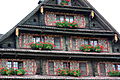
| Location | Meierskappel, Luzern-Land Constituency, Lucerne, Switzerland | ||||
| Street address |
| ||||
| Heritage designation | |||||
 | |||||
Media in category "Bauernhof Hinterspichten"
The following 3 files are in this category, out of 3 total.
-
 Bauernhof Hinterspichten, Meierskappel IMG 4777.jpg 3,088 × 2,056; 3.57 MB
-
 Bauernhof Hinterspichten, Meierskappel IMG 4778.jpg 3,088 × 2,056; 2.54 MB
-
 Bauernhof Hinterspichten, Meierskappel IMG 4779.jpg 2,056 × 3,088; 3.06 MB

