Category:Bottom Lock, Trent and Mersey Canal
Jump to navigation
Jump to search
| Object location | | View all coordinates using: OpenStreetMap |
|---|
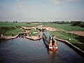
Bottom Lock on the Trent and Mersey Canal, Church Lawton, Cheshire East, England.
Not to be confused with Lawton Bottom Lock (lock 52).
Lock number 48 on the Trent and Mersey Canal.
Grade II listed canal lock in Church Lawton, Cheshire, UK  | |||||
| Upload media | |||||
| Instance of |
| ||||
|---|---|---|---|---|---|
| Part of | |||||
| Location | Church Lawton, Cheshire East, Cheshire, North West England, England | ||||
| Architect |
| ||||
| Heritage designation |
| ||||
| Inception |
| ||||
| Significant event | |||||
 | |||||
Subcategories
This category has only the following subcategory.
Media in category "Bottom Lock, Trent and Mersey Canal"
The following 7 files are in this category, out of 7 total.
-
 Church Lawton - geograph.org.uk - 3854.jpg 640 × 480; 68 KB
-
 Church Lawton Locks No 48, Cheshire - geograph.org.uk - 2928212.jpg 1,024 × 678; 423 KB
-
 Church Lawton Locks No 48, Cheshire - geograph.org.uk - 2928217.jpg 600 × 800; 306 KB
-
 Church Locks No. 48.jpg 4,160 × 3,120; 3.15 MB
-

-

-


