Category:Château des Rôdeurs
Jump to navigation
Jump to search
| Object location | | View all coordinates using: OpenStreetMap |
|---|
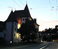
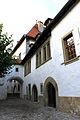
castle building in Lutry in the canton of Vaud, Switzerland  | |||||
| Upload media | |||||
| Instance of | |||||
|---|---|---|---|---|---|
| Part of |
| ||||
| Location | Lutry, Lavaux-Oron District, canton Vaud, Switzerland | ||||
| Street address |
| ||||
| Heritage designation | |||||
 | |||||
Media in category "Château des Rôdeurs"
The following 18 files are in this category, out of 18 total.
-
 Château des Rôdeurs 1.JPG 4,000 × 3,000; 1.95 MB
-
 Château des Rôdeurs 2.JPG 4,000 × 3,000; 2.56 MB
-
 Château des Rôdeurs 3.JPG 3,000 × 4,000; 2.81 MB
-
 Château des Rôdeurs 4.JPG 3,000 × 4,000; 2.75 MB
-
 Château des Rôdeurs 5.JPG 3,000 × 4,000; 2.64 MB
-
 Château des Rôdeurs à Lutry, canon.jpg 4,752 × 3,168; 1.67 MB
-
 Château des Rôdeurs à Lutry, de nuit.jpg 2,853 × 4,567; 1.04 MB
-
 Château des Rôdeurs à Lutry, détail.jpg 4,752 × 3,168; 1.54 MB
-
 Château des Rôdeurs à Lutry, façade extérieure.jpg 3,135 × 4,233; 1.17 MB
-
 Château des Rôdeurs à Lutry, façade.jpg 2,908 × 4,601; 1.06 MB
-
 Château des Rôdeurs à Lutry, nuit bis.jpg 3,168 × 4,752; 1.31 MB
-
 Château des Rôdeurs à Lutry, nuit ter.jpg 3,731 × 3,168; 732 KB
-
 Château des Rôdeurs à Lutry, portique.jpg 3,155 × 3,884; 1.08 MB
-
 Château des Rôdeurs à Lutry, singe.jpg 3,127 × 3,987; 1.12 MB
-
 Château des Rôdeurs à Lutry.jpg 3,168 × 4,752; 1.39 MB
-
 Lutry Schloss 01.JPG 4,000 × 3,000; 2.23 MB
-
 Lutry Schloss.JPG 3,000 × 4,000; 2.66 MB
-
 Schloss Lutry.jpg 2,304 × 3,072; 1.41 MB


