Category:Church in Naugarten
Jump to navigation
Jump to search
| Object location | | View all coordinates using: OpenStreetMap |
|---|
 | |||||
| Upload media | |||||
| Instance of | |||||
|---|---|---|---|---|---|
| Location | Naugarten, Nordwestuckermark, Uckermark District, Brandenburg, Germany | ||||
| Heritage designation | |||||
 | |||||
This is the category of the Brandenburger Baudenkmal (cultural heritage monument) with the ID 09130572 (Wikidata)
|
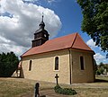
Deutsch: Ansichten der Kirche in Naugarten, Gemeinde Nordwestuckermark, Landkreis Uckermark, Land Brandenburg, Deutschland.
English: Pictures of the church in Naugarten, Nordwestuckermark municipality, Uckermark district, Brandenburg state, Germany
Français : Photos de l'église à Naugarten, commune de Nordwestuckermark, arrondissement de Uckermark, état fédéral de Brandebourg, Allemagne
Media in category "Church in Naugarten"
The following 10 files are in this category, out of 10 total.
-
 Dorfkirche Naugarten 2018 NE.jpg 4,730 × 3,464; 5.5 MB
-
 Dorfkirche Naugarten 2018 NNW.jpg 5,642 × 4,661; 7.02 MB
-
 Dorfkirche Naugarten 2018 Nordwand.jpg 3,648 × 4,864; 6.32 MB
-
 Dorfkirche Naugarten 2018 SE.jpg 5,376 × 4,847; 10.1 MB
-
 Dorfkirche Naugarten 2018 SW.jpg 4,501 × 4,704; 8.31 MB
-
 Dorfkirche Naugarten 2018 Südwestportal.jpg 4,864 × 3,648; 5.18 MB
-
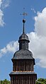 Dorfkirche Naugarten 2018 Turmhaube.jpg 1,213 × 2,223; 796 KB
-
 Dorfkirche Naugarten 2018 W.jpg 3,514 × 4,766; 5.85 MB
-
 Dorfkirche und Friedhofsmauer in Naugarten 2018 NE.jpg 4,864 × 3,648; 5.67 MB
-
 Naugarten 05 18 07 jiw.jpg 1,920 × 1,280; 720 KB


