Category:Dorfkirche Börnicke (Bernau)
Jump to navigation
Jump to search
| Object location | | View all coordinates using: OpenStreetMap |
|---|
church building in Brandenburg state, Germany   | |||||
| Upload media | |||||
| Instance of | |||||
|---|---|---|---|---|---|
| Location | Börnicke, Bernau bei Berlin, Barnim District, Brandenburg, Germany | ||||
| Heritage designation | |||||
 | |||||
This is the category of the Brandenburger Baudenkmal (cultural heritage monument) with the ID 09175353 (Wikidata)
|
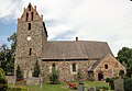
English: Pictures of the church in Börnicke, Bernau bei Berlin municipality, Barnim district, Brandenburg state, Germany. It is owned and used by a Lutheran congregation within the Evangelical Church of Berlin-Brandenburg-Silesian Upper Lusatia, a united Protestant church body of Calvinist, Lutheran and united congregations.
Deutsch: Ansichten der Kirche in Börnicke, Stadt Bernau bei Berlin, Landkreis Barnim, Land Brandenburg, Deutschland. Sie gehört und dient einer lutherischen Gemeinde der unierten Evangelischen Kirche Berlin-Brandenburg-Schlesische Oberlausitz.
Français : Photos de l'église à Börnicke, ville de Bernau bei Berlin, arrondissement de Barnim, état fédéral de Brandebourg, Allemagne
Español: Vistas de la iglesia en Börnicke, ciudad de Bernau bei Berlin, distrito de Barnim, estado federado de Brandeburgo, Alemania
Address:
Ernst-Thälmann-Straße 15, Börnicke, 16321 Bernau bei Berlin
Subcategories
This category has only the following subcategory.
Media in category "Dorfkirche Börnicke (Bernau)"
The following 8 files are in this category, out of 8 total.
-
 Dorfkirche Börnicke (Bernau) 2015 E.jpg 2,592 × 1,944; 2.67 MB
-
 Dorfkirche Börnicke (Bernau) 2015 NE.jpg 2,592 × 1,944; 2.7 MB
-
 Dorfkirche Börnicke (Bernau) 2015 S.jpg 2,738 × 1,884; 2.37 MB
-
 Bernau bei Berlin OT Börnicke Kirche.JPG 2,949 × 1,910; 1.16 MB
-
 Boernicke - Dorfkirche (Village Church) - geo.hlipp.de - 29031.jpg 640 × 480; 103 KB
-
 Boernicke church.jpg 1,830 × 1,470; 458 KB
-
 Boernicke Ernst von Mendelssohn Bartholdy.jpg 1,680 × 1,470; 591 KB
-
 Boernicke Paul von Mendelssohn Bartholdy.jpg 1,650 × 1,470; 636 KB
_2015_E.jpg)
_2015_NE.jpg)
_2015_S.jpg)

_-_geo.hlipp.de_-_29031.jpg)

