Category:Dorfkirche Hindenberg (Lübbenau)
Jump to navigation
Jump to search
| Object location | | View all coordinates using: OpenStreetMap |
|---|
This is the category of the Brandenburger Baudenkmal (cultural heritage monument) with the ID 09120063 (Wikidata)
|
church   | |||||
| Upload media | |||||
| Instance of | |||||
|---|---|---|---|---|---|
| Location | Hindenberg (Lübbenau), Lübbenau, Oberspreewald-Lausitz District, Brandenburg, Germany | ||||
| Heritage designation | |||||
 | |||||
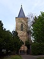
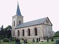
English: Pictures of the church in Hindenberg, Lübbenau/Spreewald municipality, Oberspreewald-Lausitz district, Brandenburg state, Germany.
Deutsch: Ansichten der Kirche in Hindenberg, Stadt Lübbenau/Spreewald, Landkreis Oberspreewald-Lausitz, Land Brandenburg, Deutschland.
Media in category "Dorfkirche Hindenberg (Lübbenau)"
The following 6 files are in this category, out of 6 total.
-
 Dorfkirche Hindenberg 2022-04-30.jpg 3,456 × 4,608; 7.8 MB
-
 Dorfkirche Hindenberg NO 2022.jpg 4,032 × 3,024; 3.05 MB
-
 Dorfkirche Hindenberg Portal 2022.jpg 3,024 × 4,032; 4.81 MB
-
 Dorfkirche Hindenberg SO 2022.jpg 4,032 × 3,024; 3.6 MB
-
 Dorfkirche Hindenberg Turm 2022.jpg 2,592 × 4,608; 3.55 MB
-
 Hindenberg Kirche.JPG 640 × 480; 32 KB


