Category:Dorfkirche Markgrafpieske
Jump to navigation
Jump to search
| Object location | | View all coordinates using: OpenStreetMap |
|---|
church building in Brandenburg state, Germany  | |||||
| Upload media | |||||
| Instance of | |||||
|---|---|---|---|---|---|
| Location | Markgrafpieske, Spreenhagen, Oder-Spree District, Brandenburg, Germany | ||||
| Street address |
| ||||
| Heritage designation | |||||
 | |||||
This is the category of the Brandenburger Baudenkmal (cultural heritage monument) with the ID 09115325 (Wikidata)
|
Media in category "Dorfkirche Markgrafpieske"
The following 5 files are in this category, out of 5 total.
-
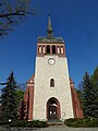
 Church of Markgrafpieske.jpg 900 × 600; 148 KB
-
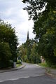
 Dorfkirche Markgrafpieske Blick vom Ortseingang.jpg 2,592 × 1,944; 2.76 MB
-
 Dorfkirche Markgrafpieske Nordansicht.jpg 2,592 × 1,944; 2.61 MB
-
 Dorfkirche Markgrafpieske Ostturm.jpg 1,944 × 2,592; 1.94 MB
-
 Kirche Markgrafpieske.JPG 3,072 × 4,608; 6.13 MB


