Category:Dorfkirche Neuendorf
Jump to navigation
Jump to search
| Object location | | View all coordinates using: OpenStreetMap |
|---|
church builduing in Barnim district, Brandenburg state, Germany  | |||||
| Upload media | |||||
| Instance of | |||||
|---|---|---|---|---|---|
| Location | Oderberg, Barnim District, Brandenburg, Germany | ||||
| Heritage designation | |||||
 | |||||
This is the category of the Brandenburger Baudenkmal (cultural heritage monument) with the ID 09175287 (Wikidata)
|
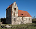
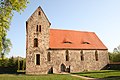
English: Church of Neuendorf, Oderberg municipality, Barnim district, Brandenburg state, Germany
Deutsch: Kirche von Neuendorf, Gemeinde Oderberg, Landkreis Barnim, Land Brandenburg, Deutschland
Media in category "Dorfkirche Neuendorf"
The following 8 files are in this category, out of 8 total.
-
 2010-02-20-oderberg-by-RalfR-20.jpg 4,288 × 2,848; 4.94 MB
-
 2010-02-20-oderberg-by-RalfR-21.jpg 2,848 × 2,848; 3.73 MB
-
 2010-02-20-oderberg-by-RalfR-22.jpg 4,288 × 2,848; 6.49 MB
-
 2010-02-20-oderberg-by-RalfR-24.jpg 2,848 × 4,288; 5.23 MB
-
 2010-02-20-oderberg-by-RalfR-44.jpg 4,288 × 2,848; 4.47 MB
-
 Neuendorf church SE.jpg 2,960 × 2,264; 983 KB
-
 Neuendorf church SW.jpg 2,800 × 2,304; 833 KB
-
 Wehrkirche Neuendorf.JPG 3,888 × 2,592; 4.13 MB


