Category:Dorfkirche Ruhlsdorf (Strausberg)
Jump to navigation
Jump to search
| Object location | | View all coordinates using: OpenStreetMap |
|---|
 | |||||
| Upload media | |||||
| Instance of | |||||
|---|---|---|---|---|---|
| Location | Ruhlsdorf (Strausberg), Strausberg, Märkisch-Oderland District, Brandenburg, Germany | ||||
| Heritage designation | |||||
 | |||||
This is the category of the Brandenburger Baudenkmal (cultural heritage monument) with the ID 09180180 (Wikidata)
|
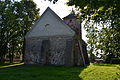
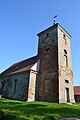
Deutsch: Bilder der Kirche in Ruhlsdorf, Stadt Strausberg, Landkreis Märkisch-Oderland, Land Brandenburg, Deutschland.
English: Pictures of the church in Ruhlsdorf, Strausberg municipality, Märkisch-Oderland district, Brandenburg state, Germany
Français : Photos de l'église à Ruhlsdorf, ville de Strausberg, arrondissement de Märkisch-Oderland, état fédéral de Brandebourg, Allemagne
Media in category "Dorfkirche Ruhlsdorf (Strausberg)"
The following 8 files are in this category, out of 8 total.
-
 Strausberg - Ruhlsdorf - Kirche - 04.JPG 4,608 × 3,072; 7.63 MB
-
 Strausberg - Ruhlsdorf - Kirche - 06.JPG 4,608 × 3,072; 8.14 MB
-
 Strausberg - Ruhlsdorf - Kirche - 07.JPG 4,608 × 3,072; 8.12 MB
-
 Strausberg - Ruhlsdorf - Kirche - 08.JPG 3,072 × 4,608; 7.47 MB
-
 Strausberg - Ruhlsdorf - Kirche - 09.JPG 3,072 × 4,608; 7.42 MB
-
 Strausberg - Ruhlsdorf - Kirche - 10.jpg 3,072 × 4,608; 5.64 MB
-
 Strausberg - Ruhlsdorf - Kirche - 11.JPG 4,608 × 3,072; 6.19 MB
-
 Strausberg - Ruhlsdorf - Kirche - 12.JPG 3,072 × 4,608; 7.48 MB


