Category:Dorfkirche Schildow
Jump to navigation
Jump to search
| Object location | | View all coordinates using: OpenStreetMap |
|---|
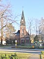
church building in Oberhavel district, Brandenburg state, Germany  | |||||
| Upload media | |||||
| Instance of | |||||
|---|---|---|---|---|---|
| Location | Schildow, Mühlenbecker Land, Oberhavel District, Brandenburg, Germany | ||||
| Heritage designation | |||||
 | |||||
This is the category of the Brandenburger Baudenkmal (cultural heritage monument) with the ID 09165307 (Wikidata)
|
English: Church in Schildow, Mühlenbecker Land municipality, Oberhavel district, Brandenburg state, Germany
Deutsch: Dorfkirche in Schildow, Gemeinde Mühlenbecker Land, Landkreis Oberhavel, Land Brandenburg, Deutschland
Français : Église de Schildow, commune de Mühlenbecker Land, arrondissement de Haute-Havel, état fédéral de Brandebourg, Allemagne
Subcategories
This category has only the following subcategory.
I
Media in category "Dorfkirche Schildow"
The following 9 files are in this category, out of 9 total.
-
 Dorfkirche Schildow, 2024-04-07, hinter Baum.jpg 3,072 × 4,080; 7.05 MB
-
 Dorfkirche Schildow, 2024-04-07.jpg 3,072 × 4,080; 6 MB
-
 Dorfkirche Schildow.jpg 3,456 × 5,184; 10.13 MB
-
 Schildow church 2013 SW.jpg 2,333 × 2,450; 3.97 MB
-
 Schildow church 2013 W.jpg 2,448 × 3,264; 3.25 MB
-
 Schildow church 2013 WNW.jpg 2,448 × 3,264; 4.61 MB
-
 Schildow church 2016 N.jpg 3,648 × 4,864; 5.12 MB
-
 Schildow church 2016 portal W.jpg 3,648 × 4,864; 5.91 MB
-
 Schildow Dorfkirche.JPG 2,370 × 4,018; 1.66 MB


