Category:Glarner Hauptüberschiebung
Vai alla navigazione
Vai alla ricerca
|
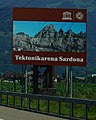
Questo sito è inserito nell'elenco del Patrimonio Mondiale dell'UNESCO sotto l'intitolazione :
Swiss Tectonic Arena Sardona.
|
landform  | |||||
| Carica un file multimediale | |||||
| Istanza di |
| ||||
|---|---|---|---|---|---|
| Luogo | Grigioni, Svizzera | ||||
| Designazione del patrimonio |
| ||||
| Catena montuosa |
| ||||
| Punto più alto | |||||
| Superficie |
| ||||
| sito web ufficiale | |||||
 | |||||
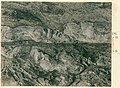
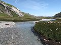
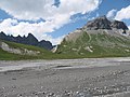
Glarus thrust is a geological phenomenon where a clearly visible line divides older rock lying on younger rock. A copy of one location is exhibited in the American Museum of Natural History, New York. It became a UNESCO world heritage site under the name "Swiss Tectonic Arena Sardona."
Sottocategorie
Questa categoria contiene le 6 sottocategorie indicate di seguito, su un totale di 6.
File nella categoria "Glarner Hauptüberschiebung"
Questa categoria contiene 31 file, indicati di seguito, su un totale di 31.
-
 20180619 WalenseeHwy 5649 (48402931772).jpg 7 952 × 5 304; 26,97 MB
-
 Attraction Switzerland winter walk cassons.jpg 2 592 × 1 472; 1,06 MB
-
 Dolf vom Fil de Cassons.jpg 860 × 722; 235 KB
-
 Dolf vom Segnesboden.jpg 860 × 571; 200 KB
-
 ETH-BIB-Lochseite, Schwanden von Südwest mit Herrn Gränicher-Dia 247-15337.tif 3 660 × 2 772; 9,76 MB
-
 ETH-BIB-Lochseite, Übersicht-Dia 247-00056.tif 3 585 × 2 776; 9,6 MB
-
 Flimser Wasserweg 14.jpg 2 048 × 1 536; 1,57 MB
-
 Flimser Wasserweg 15.jpg 2 048 × 1 536; 1,55 MB
-
 Flimser Wasserweg 16.jpg 2 048 × 1 536; 1,48 MB
-
 Flimser Wasserweg 18 Unterer Segnesboden.jpg 2 048 × 1 536; 1,59 MB
-
 Glarner Hauptüberschiebung am Segnes 2008 SE.jpg 3 262 × 2 174; 2,46 MB
-
 Glarus Thrust Fault at Piz Segnes.JPG 3 264 × 745; 797 KB
-
 Glarus Thrust Fault in Switzerland 2018 - Stitched Panorama.jpg 14 564 × 4 725; 6,86 MB
-
 Glarus Thrust Fault in Switzerland 2018.jpg 4 608 × 3 456; 6,97 MB
-
 Hauptüberschiebung Nahaufnahme.jpg 4 608 × 2 592; 2,73 MB
-
 Hauptüberschiebung Segnesboden.JPG 2 048 × 1 536; 1,49 MB
-
 Hauptüberschiebung Tschepband.jpg 4 608 × 2 592; 2,6 MB
-
 Hike Switzerland on Cassons to find different rocks.jpg 2 592 × 1 456; 1,29 MB
-
 Hiking Switzerland Piz Dolf from Fil de Cassons.jpg 704 × 568; 177 KB
-
 In der Schweiz wandern Fil de Cassons Schichten.jpg 2 592 × 1 944; 1,44 MB
-
 Lochsite Hs 0401-0298.jpg 3 890 × 2 987; 11,77 MB
-
 Lochsite Hs 0401-1346.jpg 2 833 × 2 076; 6,51 MB
-
 Martinsloch 077k.jpg 2 302 × 1 712; 1,23 MB
-
 Schweiz Wandern zur Tektonikarena Sardona.jpg 2 431 × 1 689; 934 KB
-
 Segnas, sardona.jpg 860 × 562; 192 KB
-
 Segnesboden-Martinsloch.jpg 1 240 × 930; 310 KB
-
 Tektonikarena Sardona, tourist road sign on A3, 2018.jpg 919 × 1 146; 823 KB
-
 Tenna and Flims from Sarner Höhi (Sarn-Heinzenberg).jpg 2 592 × 1 944; 1,36 MB
-
 Verrucanoüberschiebung Hs 0401-1341.jpg 4 113 × 3 261; 11,41 MB
-
 Wandern Schweiz Überschiebungslinie Glarner H.jpg 2 592 × 1 936; 3,07 MB
-
 WelterbeSardona Fronalp.jpg 2 448 × 3 264; 6,43 MB
.jpg)


.jpg)


