Category:Great Polish Map of Scotland (sculpture)
Jump to navigation
Jump to search
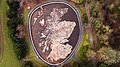
English: Great Polish Map of Scotland sculpture — at Barony Castle near Eddleston, in Peebles burgh of the Scottish Borders, southeastern Scotland.
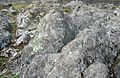
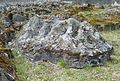
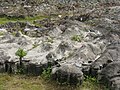
- A large 40 metres (130 ft) × 50 metres (160 ft) outdoor concrete sculpture is a scale terrain relief model of Scotland (built 1974-1979), to honor the WW II 1st Polish Corps stationed at the castle.
outdoor concrete scale model of Scotland  | |||||
| Upload media | |||||
| Instance of |
| ||||
|---|---|---|---|---|---|
| Depicts | Scotland | ||||
| Made from material | |||||
| Location |
| ||||
| Heritage designation |
| ||||
| Date of official opening |
| ||||
| Significant event |
| ||||
| Width |
| ||||
| Length |
| ||||
 | |||||
Media in category "Great Polish Map of Scotland (sculpture)"
The following 80 files are in this category, out of 80 total.
-
 'Scotland' and Moray Firth from 'Duncansby Head' - geograph.org.uk - 1934919.jpg 2,640 × 1,980; 1.24 MB
-
 The Great Polish Map Of Scotland (Mapa Scotland), Barony Castle.JPG 2,400 × 1,349; 1.37 MB
-
 West Coast of Scotland, Barony Castle Map, Peebleshire.JPG 4,000 × 2,660; 3.31 MB
-
 Above Winter View.jpg 3,968 × 2,976; 9.55 MB
-
 Barony Castle map of Scotland, Eddleston - geograph.org.uk - 2373408.jpg 640 × 480; 141 KB
-

-
 Barony Castle map of Scotland, Galloway - geograph.org.uk - 2373411.jpg 640 × 480; 160 KB
-

-

-
 Ben Nevis, Barony Castle Map, Peebleshire.JPG 3,888 × 2,533; 3.01 MB
-
 Caithness and Sutherland - geograph.org.uk - 4934537.jpg 3,264 × 2,448; 4.16 MB
-

-
 Clean-up results at Great Polish Map of Scotland - geograph.org.uk - 3858305.jpg 1,024 × 678; 307 KB
-
 Digitising the Great Polish Map of Scotland - geograph.org.uk - 5505230.jpg 1,600 × 1,159; 455 KB
-
 East coast of the Great Polish Map of Scotland - geograph.org.uk - 5121715.jpg 1,024 × 682; 255 KB
-
 Forth Estuary and Fife, Mapa Scotland, Barony Castle.JPG 2,560 × 1,920; 1.74 MB
-
 Frozen sea at the Great Polish Map of Scotland - geograph.org.uk - 4799048.jpg 1,024 × 678; 215 KB
-
 Galloway, Mapa Scotland, Barony Castle.JPG 2,560 × 1,920; 1.77 MB
-
 Great Polish Map of Scotland - geograph.org.uk - 5323947.jpg 640 × 427; 439 KB
-
 Isle of Arran, Mapa Scotland, Barony Castle.JPG 3,973 × 2,672; 3.39 MB
-
 Kintyre, Arran and the Firth of Clyde - geograph.org.uk - 4934545.jpg 3,264 × 2,448; 5.3 MB
-
 Leak testing the seabed at the Great Polish Map - geograph.org.uk - 4774079.jpg 2,560 × 1,536; 1.76 MB
-
 Map of Scotland under snow - geograph.org.uk - 4314067.jpg 1,024 × 682; 186 KB
-
 Mapa Scotland - geograph.org.uk - 5323937.jpg 427 × 640; 413 KB
-
 Mapa Scotland, Barony Castle, Scottish Borders.JPG 2,132 × 856; 748 KB
-
 Memorial bench to Kim Traynor, Geographer - geograph.org.uk - 4894195.jpg 1,024 × 682; 291 KB
-

-

-
 Ochil Hills, Mapa Scotland, Barony Castle.JPG 2,246 × 1,197; 790 KB
-
 Overview of the Great Polish Map of Scotland - geograph.org.uk - 5121674.jpg 1,024 × 682; 249 KB
-
 Relief model of Scotland - geograph.org.uk - 881306.jpg 640 × 480; 146 KB
-

-

-

-

-

-

-

-

-

-

-

-

-

-

-

-
 Restoration work, Great Polish Map of Scotland - geograph.org.uk - 4207082.jpg 1,024 × 682; 280 KB
-
 Scottish Borders - Great Polish Map of Scotland - 20230304103005.jpeg 4,032 × 3,024; 11.1 MB
-

-
 Strengthening Scottish-Polish ties (27540705448).jpg 6,720 × 4,480; 14.98 MB
-
 Strengthening Scottish-Polish ties (41412036651).jpg 6,189 × 4,022; 12.64 MB
-

-
 The Firths of Forth and Tay - geograph.org.uk - 4934553.jpg 3,264 × 2,448; 5.2 MB
-
 The GREAT POLISH MAP OF SCOTLAND - 2015 - geograph.org.uk - 4565637.jpg 3,264 × 2,448; 5.21 MB
-
 The GREAT POLISH MAP OF SCOTLAND - 2015 - geograph.org.uk - 4565656.jpg 3,264 × 2,448; 5.99 MB
-
 The GREAT POLISH MAP OF SCOTLAND - 2015 - geograph.org.uk - 4565669.jpg 3,264 × 2,448; 5.12 MB
-
 The GREAT POLISH MAP OF SCOTLAND - 2015 - geograph.org.uk - 4565684.jpg 3,264 × 2,448; 3.34 MB
-
 The Great Polish Map of Scotland - geograph.org.uk - 3593261.jpg 3,264 × 2,448; 5.91 MB
-
 The Great Polish Map of Scotland - geograph.org.uk - 3593278.jpg 3,264 × 2,448; 5.42 MB
-
 The Great Polish Map of Scotland - geograph.org.uk - 3593291.jpg 3,264 × 2,448; 5.7 MB
-
 The Great Polish Map of Scotland - geograph.org.uk - 3593311.jpg 3,264 × 2,448; 6 MB
-
 The Great Polish Map of Scotland - geograph.org.uk - 3593324.jpg 3,264 × 2,448; 5.91 MB
-
 The Great Polish Map of Scotland - geograph.org.uk - 3593335.jpg 3,264 × 2,448; 5.84 MB
-
 The Great Polish Map of Scotland - geograph.org.uk - 3593343.jpg 3,264 × 2,448; 5.91 MB
-
 The Great Polish Map of Scotland - geograph.org.uk - 3593350.jpg 3,264 × 2,448; 6.03 MB
-
 The Great Polish Map of Scotland - geograph.org.uk - 3593359.jpg 3,264 × 2,448; 6.07 MB
-
 The Great Polish Map of Scotland - geograph.org.uk - 3593369.jpg 3,264 × 2,448; 5.74 MB
-
 The Great Polish Map of Scotland - geograph.org.uk - 3593375.jpg 3,264 × 2,448; 5.81 MB
-
 The Great Polish Map of Scotland - geograph.org.uk - 3601382.jpg 640 × 253; 68 KB
-
 The GREAT POLISH MAP OF SCOTLAND - geograph.org.uk - 4565706.jpg 3,234 × 1,782; 1.71 MB
-
 The GREAT POLISH MAP OF SCOTLAND - geograph.org.uk - 4565716.jpg 2,847 × 1,380; 1.27 MB
-
 The GREAT POLISH MAP OF SCOTLAND - geograph.org.uk - 4565723.jpg 3,071 × 1,458; 1.45 MB
-
 The Great Polish Map of Scotland - geograph.org.uk - 4887145.jpg 660 × 371; 103 KB
-

-
 The Great Polish Map of Scotland.JPG 4,000 × 2,250; 4.21 MB
-
 The Minch and Outer Hebrides - geograph.org.uk - 4934568.jpg 3,264 × 2,448; 4.25 MB
-

-
 West coast of the Great Polish Map of Scotland - geograph.org.uk - 5121693.jpg 1,024 × 682; 215 KB
-
 Winter sun on the 'Cairngorms' - geograph.org.uk - 4269211.jpg 1,024 × 682; 199 KB
-
 Outer Hebrides, Mapa Scotland, Barony Castle.JPG 1,920 × 2,560; 1.74 MB

,_Barony_Castle.JPG)


_-_geograph.org.uk_-_4682578.jpg)
_-_geograph.org.uk_-_4682586.jpg)
_-_geograph.org.uk_-_4861950.jpg)
_-_geograph.org.uk_-_5255127.jpg)
_-_geograph.org.uk_-_5255132.jpg)
_-_geograph.org.uk_-_5282259.jpg)
_-_geograph.org.uk_-_5287783.jpg)
_-_geograph.org.uk_-_4207258.jpg)
_-_geograph.org.uk_-_4207283.jpg)
_-_geograph.org.uk_-_4269205.jpg)
_-_geograph.org.uk_-_4384194.jpg)
_-_geograph.org.uk_-_4600263.jpg)
_-_geograph.org.uk_-_4600292.jpg)
_-_geograph.org.uk_-_4600308.jpg)
_-_geograph.org.uk_-_4637844.jpg)


.jpg)
.jpg)


Categories:
- Topographic maps of Scotland
- Barony Castle
- Concrete sculptures in Scotland
- Outdoor sculptures in Scotland
- Installation art in the United Kingdom
- Sculptures in the Scottish Borders
- War memorials in the Scottish Borders
- Polish diaspora in the United Kingdom
- Built in the United Kingdom in 1975
- Category B listed war memorials
- Art from Poland
- 1975 sculptures
- 1975 in Poland
- 1975 in Scotland
- World War II memorials in Scotland
- Eddleston
- Category B listed buildings in the Scottish Borders