Category:Himmelfahrtskirche (Cranzahl)
Jump to navigation
Jump to search
| Object location | | View all coordinates using: OpenStreetMap |
|---|
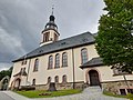
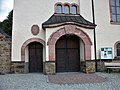
church building in Sehmatal, Germany  | |||||
| Upload media | |||||
| Instance of | |||||
|---|---|---|---|---|---|
| Location | Cranzahl, Sehmatal, Erzgebirgskreis, Saxony, Germany | ||||
| Street address |
| ||||
| Heritage designation | |||||
| Inception |
| ||||
 | |||||
| (Wikidata) |
Media in category "Himmelfahrtskirche (Cranzahl)"
The following 18 files are in this category, out of 18 total.
-
 Bärenstein, Blick vom Bärenstein zur Himmelfahrtskirche (Cranzahl).jpg 2,433 × 1,611; 1.4 MB
-
 Cranzahl 1.jpg 3,037 × 2,021; 3.58 MB
-
 Cranzahl, Sachsen - Kirche (Zeno Ansichtskarten).jpg 2,223 × 1,377; 286 KB
-
 CranzahlErzgebirgeHimmelfahrtskirche.jpg 1,280 × 960; 600 KB
-
 Ev.-luth. Himmelfahrtskirche Cranzahl (2).jpg 3,643 × 2,731; 1.45 MB
-
 Ev.-luth. Himmelfahrtskirche Cranzahl (3).jpg 2,923 × 3,896; 2.11 MB
-
 Ev.-luth. Himmelfahrtskirche Cranzahl (4).jpg 4,000 × 3,000; 2.99 MB
-
 Ev.-luth. Himmelfahrtskirche Cranzahl (5).jpg 3,024 × 4,032; 2.09 MB
-
 Ev.-luth. Himmelfahrtskirche Cranzahl (6).jpg 3,024 × 4,032; 3.56 MB
-
 Ev.-luth. Himmelfahrtskirche Cranzahl, Glocke.jpg 3,000 × 4,000; 4.36 MB
-
 Ev.-luth. Himmelfahrtskirche Cranzahl, Portal (1).jpg 4,000 × 3,000; 2.8 MB
-
 Ev.-luth. Himmelfahrtskirche Cranzahl, Portal (2).jpg 4,000 × 3,000; 2.64 MB
-
 Ev.-luth. Himmelfahrtskirche Cranzahl, Portal (3).jpg 4,032 × 3,024; 4.8 MB
-
 Ev.-luth. Himmelfahrtskirche Cranzahl, Torbogen.jpg 3,024 × 4,032; 5 MB
-
 Himmelfahrtskirche Cranzahl.png 1,014 × 686; 1.46 MB
-
 Ortsspaziergang Cranzahl, Infotafel Himmelfahrtskirche.jpg 4,000 × 3,000; 2.48 MB
-
 Pfarramt Cranzahl.jpg 4,000 × 3,000; 3.68 MB
-
 Weihnachtsberg Cranzahl (1).jpg 2,926 × 3,901; 2.21 MB
.jpg)

.jpg)
.jpg)
.jpg)
.jpg)
.jpg)
.jpg)

.jpg)
.jpg)
.jpg)


.jpg)