Category:Kienbaum church
Jump to navigation
Jump to search
| Object location | | View all coordinates using: OpenStreetMap |
|---|
church building in Brandenburg state, Germany  | |||||
| Upload media | |||||
| Instance of | |||||
|---|---|---|---|---|---|
| Location | Kienbaum, Grünheide (Mark), Oder-Spree District, Brandenburg, Germany | ||||
| Heritage designation | |||||
 | |||||
This is the category of the Brandenburger Baudenkmal (cultural heritage monument) with the ID 09115440 (Wikidata)
|
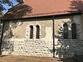
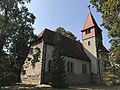
Deutsch: Bilder der Kirche in Kienbaum , Gemeinde Grünheide (Mark) , Landkreis Oder-Spree , Land Brandenburg, Deutschland.
English: Pictures of the church in Kienbaum , Grünheide (Mark) municipality , Oder-Spree district, Brandenburg state, Germany
Français : Photos de l'église à Kienbaum , commune de Grünheide (Mark) , arrondissement de Oder-Spree , état fédéral de Brandebourg, Allemagne
Media in category "Kienbaum church"
The following 29 files are in this category, out of 29 total.
-
 Dorfkirche Kienbaum 01.jpg 2,064 × 3,461; 2.82 MB
-
 Dorfkirche Kienbaum 2018 E.jpg 3,648 × 4,864; 8.11 MB
-
 Dorfkirche Kienbaum 2018 NE.jpg 4,864 × 3,648; 7.06 MB
-
 Dorfkirche Kienbaum 2018 NNE.jpg 4,864 × 3,648; 7.23 MB
-
 Dorfkirche Kienbaum 2018 NNW.jpg 3,648 × 4,864; 10.42 MB
-
 Dorfkirche Kienbaum 2018 S.jpg 4,864 × 3,648; 6.95 MB
-
 Dorfkirche Kienbaum 2018 SE.jpg 3,648 × 4,864; 5.88 MB
-
 Dorfkirche Kienbaum 2018 SW.jpg 3,648 × 4,864; 7.95 MB
-
 Dorfkirche Kienbaum 2018 Westportal.jpg 3,648 × 4,864; 6.81 MB
-
 Dorfkirche Kienbaum 2018 WNW.jpg 3,648 × 4,864; 5.94 MB
-
 Dorfkirche Kienbaum 2022-05-11 01.jpg 8,368 × 5,584; 23.64 MB
-
 Dorfkirche Kienbaum 2022-05-11 02.jpg 8,368 × 5,584; 23.46 MB
-
 Dorfkirche Kienbaum 2022-05-11 03.jpg 5,584 × 8,368; 23.37 MB
-
 Dorfkirche Kienbaum 2022-05-11 04.jpg 5,584 × 8,368; 23.03 MB
-
 Dorfkirche Kienbaum 2022-05-11 05.jpg 8,368 × 5,584; 24.94 MB
-
 Dorfkirche Kienbaum 2022-05-11 06.jpg 8,368 × 5,584; 23.47 MB
-
 Dorfkirche Kienbaum Denkmal Gefallene.jpg 3,024 × 4,032; 5.54 MB
-
 Dorfkirche Kienbaum Kirchenschiff Südseite.jpg 4,032 × 3,024; 4.51 MB
-
 Dorfkirche Kienbaum Kirchenschiff und Chor Nordansicht.jpg 4,032 × 3,024; 4.6 MB
-
 Dorfkirche Kienbaum Kirchenschiff und Sakristei Südseite.jpg 3,024 × 4,032; 3.86 MB
-
 Dorfkirche Kienbaum Nordostansicht.jpg 4,032 × 3,024; 3.91 MB
-
 Dorfkirche Kienbaum Ostansicht.jpg 4,032 × 3,024; 5.45 MB
-
 Dorfkirche Kienbaum Sakristei Westseite.jpg 3,024 × 4,032; 4.55 MB
-
 Dorfkirche Kienbaum Westansicht.jpg 3,024 × 4,032; 4.55 MB
-
 Dorfkirche Kienbaum Westportal.jpg 4,032 × 3,024; 5.17 MB
-
 Dorfkirche Kienbaum Westturm Glockengeschoss Westansicht.jpg 3,024 × 4,032; 3.84 MB
-
 Dorfkirche Kienbaum Westturm Nordansicht.jpg 3,024 × 4,032; 4.97 MB
-
 Dorfkirche Kienbaum Westturm Nordwestansicht.jpg 3,024 × 4,032; 3.87 MB
-
 Kienbaum - Dorfkirche - panoramio.jpg 480 × 640; 74 KB


