Category:Kunigundenkirche (Borna)
Jump to navigation
Jump to search
| Object location | | View all coordinates using: OpenStreetMap |
|---|
church building in Borna, Saxony, Germany   | |||||
| Upload media | |||||
| Instance of | |||||
|---|---|---|---|---|---|
| Location | Borna, Landkreis Leipzig, Saxony, Germany | ||||
| Street address |
| ||||
| Heritage designation | |||||
| Inception |
| ||||
 | |||||
Media in category "Kunigundenkirche (Borna)"
The following 19 files are in this category, out of 19 total.
-
 20090818300MDR Borna Kunigundenkirche.jpg 2,308 × 2,956; 5.53 MB
-
 20090818305DR Borna Kunigundenkirche zum Altar.jpg 1,856 × 2,392; 4.01 MB
-
 20090818310DR Borna Kunigundenkirche Altar.jpg 1,683 × 2,322; 3.42 MB
-
 20090818315DR Borna Kunigundenkirche Flügelaltar.jpg 2,280 × 1,382; 3.65 MB
-
 20090818320DR Borna Kunigundenkirche Fresken in Apsiskuppel.jpg 2,508 × 1,848; 3.41 MB
-
 20090818325DR Borna Kunigundenkirche Fresken an Nordwand.jpg 2,375 × 1,854; 2.78 MB
-
 20090818330DR Borna Kunigundenkirche Porphyrtaufstein.jpg 2,446 × 1,851; 4.04 MB
-
 23485-Borna-1925-Heldenfriedhof-Brück & Sohn Kunstverlag.jpg 1,536 × 1,000; 615 KB
-
 24576-Borna-1928-Ehrenhain mit Kunigundenkirche-Brück & Sohn Kunstverlag.jpg 1,561 × 1,000; 433 KB
-
 Borna Kunigunden2 h.JPG 3,517 × 2,597; 1.14 MB
-
 Borna Steinkreuz-1.jpg 3,937 × 2,953; 1.54 MB
-
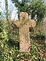 Borna Steinkreuz.jpg 3,000 × 4,000; 1.53 MB
-
 BornaKunigunde1.JPG 3,648 × 2,736; 2.1 MB
-
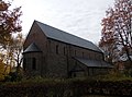 BornaKunigunden2.JPG 3,517 × 2,597; 1.26 MB
-
 BornaKunigundenkirchhof.JPG 3,648 × 2,736; 2.15 MB
-
 BornaKunigundenkirchhP.JPG 3,648 × 2,736; 1.89 MB
-
 BornaKunigundenKreuz.JPG 2,736 × 3,648; 2.29 MB
-
 BornaKunigundeSO.JPG 2,864 × 2,144; 1.57 MB
-
 Kunigundenkirche.JPG 5,184 × 3,456; 7.48 MB


