Category:Mühle mit Nebenbauten (Aumüli)
Jump to navigation
Jump to search
| Object location | | View all coordinates using: OpenStreetMap |
|---|
mill in Aumüli in the municipality of Stallikon in the canton of Zurich, Switzerland  | |||||
| Upload media | |||||
| Instance of |
| ||||
|---|---|---|---|---|---|
| Part of | |||||
| Location | |||||
| Street address |
| ||||
| Heritage designation | |||||
| Elevation above sea level |
| ||||
 | |||||
Media in category "Mühle mit Nebenbauten (Aumüli)"
The following 26 files are in this category, out of 26 total.
-
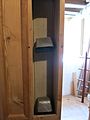
 Aumüli 1 Aufschütttrichter.jpg 2,816 × 2,112; 1.68 MB
-
 Aumüli 2 Elevatoren.jpg 2,112 × 2,816; 1.63 MB
-
 Aumüli 2 Gurtbecherwerk.jpg 2,112 × 2,816; 1.3 MB
-
 Aumüli 2 Schneckengetriebe.jpg 2,816 × 2,112; 1.89 MB
-
 Aumüli 3 Separator.jpg 2,112 × 2,816; 1.62 MB
-
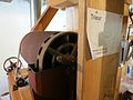
 Aumüli 4 Röllmühle.jpg 2,816 × 2,112; 1.57 MB
-
 Aumüli 5 Rendel.jpg 2,112 × 2,816; 1.44 MB
-
 Aumüli 6 Trieur.jpg 2,816 × 2,112; 1.28 MB
-
 Aumüli 7 Schälmaschine.jpg 2,112 × 2,816; 1.57 MB
-
 Aumüli 8 Mahlgang.jpg 2,816 × 2,112; 1.52 MB
-
 Aumüli 8 Mahlstuhl.jpg 2,112 × 2,816; 1.62 MB
-
 Aumüli 8 Tanzmeister.jpg 2,112 × 2,816; 1.52 MB
-
 Aumüli Kran für Läuferstein.jpg 1,600 × 1,200; 590 KB
-
 Aumüli Mahlgang.JPG 2,112 × 2,816; 1.18 MB
-
 Aumüli Mühle 2016.JPG 2,816 × 2,112; 2.29 MB
-
 Aumüli Separator.JPG 2,816 × 2,112; 1.44 MB
-
 Aumüli Trieur Schälmaschine Mahlgang.JPG 2,816 × 2,112; 1.63 MB
-
 Aumüli Trieur Schälmaschine.jpg 1,600 × 1,200; 600 KB
-
 Aumüli Unterwasser.JPG 2,112 × 2,816; 1.75 MB
-
 Aumüli Wasserrad oberschlächtig.JPG 2,816 × 2,112; 1.54 MB
-
 Aumüli Wasserrad.JPG 2,816 × 2,112; 2.04 MB
-
 Aumüli01.jpg 1,600 × 1,200; 660 KB
-
 Stallikon - Aumüli, Mühle mit Nebenbauten 2011-09-23 18-03-12.jpg 4,288 × 2,848; 5.33 MB
-
 Stallikon - Aumüli, Mühle mit Nebenbauten 2011-09-23 18-03-58.jpg 4,210 × 2,834; 4.07 MB
-
 Stallikon - Aumüli, Mühle mit Nebenbauten 2011-09-23 18-06-18.JPG 2,848 × 4,288; 2.6 MB
-
 Stallikon - Aumüli, Mühle mit Nebenbauten 2011-09-23 18-06-48 ShiftN.jpg 4,000 × 2,667; 3.33 MB


