Category:Maps by Artaria & Co.
Jump to navigation
Jump to search
Subcategories
This category has only the following subcategory.
M
Media in category "Maps by Artaria & Co."
The following 22 files are in this category, out of 22 total.
-
 1807 map of Poland.jpg 24,598 × 20,800; 83.4 MB
-
 1843 map of the Danube.jpg 17,664 × 12,401; 38.16 MB
-
 1876 map of Southern Russia, the Caucasus and part of Asia Minor.jpg 12,779 × 9,903; 28.36 MB
-
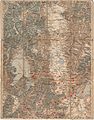
 1882 - Generalkarte von Bosnien, der Herzegovina und dem Sandschak Novi-Bazar.jpg 10,303 × 7,634; 19.26 MB
-

-
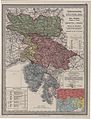
 1909 map - Königreich Bulgarien und Türkisch Thrakien.jpg 22,041 × 16,720; 93.56 MB
-
 1912 G. Freytag's Karte der Balkan-Halbinsel.jpg 20,054 × 17,573; 76.74 MB
-
 1913 map - Königreich Bulgarien und die zentralen Balkanländer zwischen Adria und Pontus.jpg 26,268 × 16,847; 107.81 MB
-
 1913 map of rail transport in Russia in Europe and Asia Minor.jpg 15,615 × 18,803; 66.56 MB
-
 1918 map - Artaria's Eisenbahnkarte von Österreich-Ungarn und den Balkanländern.jpg 18,624 × 14,270; 159.14 MB
-

-
 Artaria's Eisenbahn u. Post Communications-Karte - von OEsterreich-Ungarn - btv1b530227687.jpg 10,687 × 8,951; 16.49 MB
-

-
 Bitola map 1890.jpg 3,560 × 4,528; 3.29 MB
-
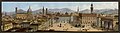 Ca. 1830 image of Piazza della Signoria Goauche, Florence.jpg 7,230 × 1,992; 1.94 MB
-
 Edessa and Environs 1890.jpg 3,496 × 4,464; 4.44 MB
-
 Gewerbliche Unterrichts-Anstalten in Österreich 1899.jpg 4,156 × 3,349; 6.91 MB
-
 Karte von America (3121046728).jpg 1,450 × 2,000; 2.88 MB
-

-
 Saloniki and Environs 1890.jpg 3,480 × 4,520; 3.92 MB
-
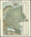
 Russlands Umgestaltung - Politische Übersicht und Haupteisenbahnen 1-6 000 000 (63647379).jpg 15,157 × 19,058; 65.4 MB
-
 Österreichisches Küstenland Gorz u. Gradiska – Istrien u. Triest – Kärnten u. Krain 1915.jpg 3,528 × 4,627; 2.82 MB


.jpg)


.jpg)
