Category:Maps of agriculture in Lot
Jump to navigation
Jump to search
Departments of Metropolitan France: Ain [01] · Aisne [02] · Allier [03] · Alpes-de-Haute-Provence [04] · Hautes-Alpes [05] · Alpes-Maritimes [06] · Ardèche [07] · Ardennes [08] · Ariège [09] · Aube [10] · Aude [11] · Aveyron [12] · Bouches-du-Rhône [13] · Calvados [14] · Cantal [15] · Charente [16] · Charente-Maritime [17] · Cher [18] · Corrèze [19] · Corse-du-Sud [2A]† · Haute-Corse [2B]† · Côte-d’Or [21] · Côtes-d'Armor [22] · Creuse [23] · Dordogne [24] · Doubs [25] · Drôme [26] · Eure [27] · Eure-et-Loir [28] · Finistère [29] · Gard [30] · Haute-Garonne [31] · Gers [32] · Gironde [33] · Hérault [34] · Ille-et-Vilaine [35] · Indre [36] · Indre-et-Loire [37] · Isère [38] · Jura [39] · Landes [40] · Loir-et-Cher [41] · Loire [42] · Haute-Loire [43] · Loire-Atlantique [44] · Loiret [45] · Lot [46] · Lot-et-Garonne [47] · Lozère [48] · Maine-et-Loire [49] · Manche [50] · Marne [51] · Haute-Marne [52] · Mayenne [53] · Meurthe-et-Moselle [54] · Meuse [55] · Morbihan [56] · Moselle [57] · Nièvre [58] · Nord [59] · Oise [60] · Orne [61] · Pas-de-Calais [62] · Puy-de-Dôme [63] · Pyrénées-Atlantiques [64] · Hautes-Pyrénées [65] · Pyrénées-Orientales [66] · Bas-Rhin [67] · Haut-Rhin [68] · Rhône [69D]‡ · Haute-Saône [70] · Saône-et-Loire [71] · Sarthe [72] · Savoie [73] · Seine-Maritime [76] · Seine-et-Marne [77] · Yvelines [78] · Deux-Sèvres [79] · Tarn [81] · Tarn-et-Garonne [82] · Var [83] · Vaucluse [84] · Vendée [85] · Vienne [86] · Haute-Vienne [87] · Vosges [88] · Yonne [89] · Territoire de Belfort [90] · Essonne [91] · Val-de-Marne [94] · Val-d'Oise [95]
Subcategories
This category has only the following subcategory.
M
- Maps of land use of communes in Lot (313 F)
Media in category "Maps of agriculture in Lot"
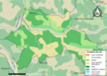
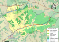
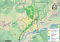
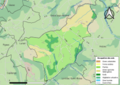
The following 200 files are in this category, out of 202 total.
(previous page) (next page)-
 46002-Albiac-Sols.png 7,015 × 4,960; 3.41 MB
-
 46003-Alvignac-Sols.png 7,015 × 4,960; 4.86 MB
-
 46004-Anglars-Sols.png 7,015 × 4,960; 6.04 MB
-
 46005-Anglars-Juillac-Sols.png 7,015 × 4,960; 4.71 MB
-
 46006-Anglars-Nozac-Sols.png 7,015 × 4,960; 6.02 MB
-
 46009-Assier-Sols.png 7,015 × 4,960; 4.74 MB
-
 46011-Autoire-Sols.png 7,015 × 4,960; 6.22 MB
-
 46012-Aynac-Sols.png 7,015 × 4,960; 7.08 MB
-
 46013-Bach-Sols.png 7,015 × 4,960; 5.72 MB
-
 46015-Bagnac-sur-Célé-Sols.png 7,015 × 4,960; 6.96 MB
-
 46016-Baladou-Sols.png 7,015 × 4,960; 4.36 MB
-
 46017-Bannes-Sols.png 7,015 × 4,960; 3.81 MB
-
 46018-Le Bastit-Sols.png 7,015 × 4,960; 4.28 MB
-
 46020-Beauregard-Sols.png 7,015 × 4,960; 4.74 MB
-
 46021-Béduer-Sols.png 7,015 × 4,960; 5.68 MB
-
 46023-Belfort-du-Quercy-Sols.png 7,015 × 4,960; 7.85 MB
-
 46024-Belmont-Bretenoux-Sols.png 7,015 × 4,960; 6.15 MB
-
 46026-Belmont-Sainte-Foi-Sols.png 7,015 × 4,960; 3.65 MB
-
 46027-Berganty-Sols.png 7,015 × 4,960; 2.83 MB
-
 46028-Bétaille-Sols.png 7,015 × 4,960; 6.27 MB
-
 46030-Bio-Sols.png 7,015 × 4,960; 4.26 MB
-
 46031-Blars-Sols.png 7,015 × 4,960; 3.35 MB
-
 46033-Porte-du-Quercy-Sols.png 7,015 × 4,960; 7.06 MB
-
 46034-Le Bourg-Sols.png 7,015 × 4,960; 5.33 MB
-
 46035-Boussac-Sols.png 7,015 × 4,960; 4.62 MB
-
 46036-Le Bouyssou-Sols.png 7,015 × 4,960; 4.03 MB
-
 46037-Bouziès-Sols.png 7,015 × 4,960; 3.05 MB
-
 46039-Brengues-Sols.png 7,015 × 4,960; 4.48 MB
-
 46040-Cabrerets-Sols.png 7,015 × 4,960; 5.38 MB
-
 46041-Cadrieu-Sols.png 7,015 × 4,960; 4.25 MB
-
 46043-Cahus-Sols.png 7,015 × 4,960; 4.16 MB
-
 46044-Caillac-Sols.png 7,015 × 4,960; 4.76 MB
-
 46045-Cajarc-Sols.png 7,015 × 4,960; 6.99 MB
-
 46046-Calamane-Sols.png 7,015 × 4,960; 3.67 MB
-
 46047-Calès-Sols.png 7,015 × 4,960; 5.93 MB
-
 46049-Calvignac-Sols.png 7,015 × 4,960; 5.27 MB
-
 46050-Cambayrac-Sols.png 7,015 × 4,960; 3.77 MB
-
 46051-Cambes-Sols.png 7,015 × 4,960; 4.07 MB
-
 46052-Camboulit-Sols.png 7,015 × 4,960; 4.16 MB
-
 46053-Camburat-Sols.png 7,015 × 4,960; 4.83 MB
-
 46054-Caniac-du-Causse-Sols.png 7,015 × 4,960; 4.23 MB
-
 46055-Capdenac-Sols.png 7,015 × 4,960; 8.82 MB
-
 46056-Carayac-Sols.png 7,015 × 4,960; 3.14 MB
-
 46058-Carennac-Sols.png 7,015 × 4,960; 6.68 MB
-
 46059-Carlucet-Sols.png 7,015 × 4,960; 5.46 MB
-
 46060-Carnac-Rouffiac-Sols.png 7,015 × 4,960; 4.8 MB
-
 46063-Castelnau-Montratier-Sainte-Alauzie-Sols.png 7,015 × 4,960; 10.96 MB
-
 46064-Catus-Sols.png 7,015 × 4,960; 5.88 MB
-
 46065-Cavagnac-Sols.png 7,015 × 4,960; 5.31 MB
-
 46066-Cazals-Sols.png 7,015 × 4,960; 4.71 MB
-
 46069-Cézac-Sols.png 7,015 × 4,960; 4.8 MB
-
 46070-Cieurac-Sols.png 7,015 × 4,960; 6.31 MB
-
 46072-Concorès-Sols.png 7,015 × 4,960; 5.99 MB
-
 46074-Condat-Sols.png 7,015 × 4,960; 5.04 MB
-
 46078-Couzou-Sols.png 7,015 × 4,960; 3.58 MB
-
 46079-Cras-Sols.png 7,015 × 4,960; 3.98 MB
-
 46080-Crayssac-Sols.png 7,015 × 4,960; 5.06 MB
-
 46083-Cressensac-Sarrazac-Sols.png 7,015 × 4,960; 5.84 MB
-
 46084-Creysse-Sols.png 7,015 × 4,960; 5.19 MB
-
 46085-Cuzac-Sols.png 7,015 × 4,960; 4.24 MB
-
 46086-Cuzance-Sols.png 7,015 × 4,960; 6.47 MB
-
 46087-Dégagnac-Sols.png 7,015 × 4,960; 7.46 MB
-
 46089-Duravel-Sols.png 7,015 × 4,960; 5.71 MB
-
 46090-Durbans-Sols.png 7,015 × 4,960; 3.82 MB
-
 46091-Escamps-Sols.png 7,015 × 4,960; 3.17 MB
-
 46093-Espagnac-Sainte-Eulalie-Sols.png 7,015 × 4,960; 3.18 MB
-
 46094-Espédaillac-Sols.png 7,015 × 4,960; 5.07 MB
-
 46100-Faycelles-Sols.png 7,015 × 4,960; 5.09 MB
-
 46101-Felzins-Sols.png 7,015 × 4,960; 5.85 MB
-
 46103-Saint-Paul-Flaugnac-Sols.png 7,015 × 4,960; 8.23 MB
-
 46104-Flaujac-Gare-Sols.png 7,015 × 4,960; 2.75 MB
-
 46107-Floressas-Sols.png 7,015 × 4,960; 5.22 MB
-
 46108-Fons-Sols.png 7,015 × 4,960; 5.73 MB
-
 46109-Fontanes-Sols.png 7,015 × 4,960; 5.64 MB
-
 46111-Fourmagnac-Sols.png 7,015 × 4,960; 4.83 MB
-
 46113-Frayssinet-Sols.png 7,015 × 4,960; 5.91 MB
-
 46115-Frayssinhes-Sols.png 7,015 × 4,960; 4.85 MB
-
 46116-Frontenac-Sols.png 7,015 × 4,960; 3.01 MB
-
 46118-Gignac-Sols.png 7,015 × 4,960; 5.9 MB
-
 46119-Gigouzac-Sols.png 7,015 × 4,960; 4.67 MB
-
 46120-Gindou-Sols.png 7,015 × 4,960; 7.1 MB
-
 46121-Ginouillac-Sols.png 7,015 × 4,960; 3.76 MB
-
 46123-Girac-Sols.png 7,015 × 4,960; 6.65 MB
-
 46124-Glanes-Sols.png 7,015 × 4,960; 4.43 MB
-
 46125-Gorses-Sols.png 7,015 × 4,960; 7.35 MB
-
 46126-Goujounac-Sols.png 7,015 × 4,960; 4.95 MB
-
 46127-Gourdon-Sols.png 7,015 × 4,960; 9.24 MB
-
 46128-Gramat-Sols.png 7,015 × 4,960; 8.03 MB
-
 46129-Gréalou-Sols.png 7,015 × 4,960; 3.16 MB
-
 46131-Grèzes-Sols.png 7,015 × 4,960; 2.48 MB
-
 46132-Issendolus-Sols.png 7,015 × 4,960; 4.62 MB
-
 46133-Issepts-Sols.png 7,015 × 4,960; 4.03 MB
-
 46135-Labastide-du-Haut-Mont-Sols.png 7,015 × 4,960; 3.63 MB
-
 46140-Laburgade-Sols.png 7,015 × 4,960; 4.77 MB
-
 46142-Lacapelle-Cabanac-Sols.png 7,015 × 4,960; 3.82 MB
-
 46143-Lacapelle-Marival-Sols.png 7,015 × 4,960; 5.1 MB
-
 46146-Ladirat-Sols.png 7,015 × 4,960; 5.19 MB
-
 46147-Lagardelle-Sols.png 7,015 × 4,960; 4.92 MB
-
 46148-Lalbenque-Sols.png 7,015 × 4,960; 6.73 MB
-
 46151-Lamothe-Cassel-Sols.png 7,015 × 4,960; 4.27 MB
-
 46152-Lamothe-Fénelon-Sols.png 7,015 × 4,960; 5.65 MB
-
 46154-Laramière-Sols.png 7,015 × 4,960; 4.93 MB
-
 46160-Latronquière-Sols.png 7,015 × 4,960; 5.05 MB
-
 46161-Lauresses-Sols.png 7,015 × 4,960; 6.65 MB
-
 46162-Lauzès-Sols.png 7,015 × 4,960; 3.54 MB
-
 46164-Lavercantière-Sols.png 7,015 × 4,960; 4.76 MB
-
 46165-Lavergne-Sols.png 7,015 × 4,960; 6.07 MB
-
 46170-Leyme-Sols.png 7,015 × 4,960; 6.9 MB
-
 46172-Lhospitalet-Sols.png 7,015 × 4,960; 4.23 MB
-
 46174-Linac-Sols.png 7,015 × 4,960; 6.22 MB
-
 46175-Lissac-et-Mouret-Sols.png 7,015 × 4,960; 5.56 MB
-
 46176-Livernon-Sols.png 7,015 × 4,960; 4.93 MB
-
 46177-Loubressac-Sols.png 7,015 × 4,960; 6.47 MB
-
 46178-Loupiac-Sols.png 7,015 × 4,960; 4.69 MB
-
 46180-Lunan-Sols.png 7,015 × 4,960; 7.41 MB
-
 46181-Lunegarde-Sols.png 7,015 × 4,960; 2.82 MB
-
 46185-Martel-Sols.png 7,015 × 4,960; 8.14 MB
-
 46186-Masclat-Sols.png 7,015 × 4,960; 4.61 MB
-
 46187-Mauroux-Sols.png 7,015 × 4,960; 4.44 MB
-
 46189-Mayrinhac-Lentour-Sols.png 7,015 × 4,960; 5.21 MB
-
 46190-Mechmont-Sols.png 7,015 × 4,960; 4.28 MB
-
 46191-Mercuès-Sols.png 7,015 × 4,960; 6.01 MB
-
 46192-Meyronne-Sols.png 7,015 × 4,960; 5.65 MB
-
 46193-Miers-Sols.png 7,015 × 4,960; 4.43 MB
-
 46198-Montbrun-Sols.png 7,015 × 4,960; 4.89 MB
-
 46201-Montcuq-en-Quercy-Blanc-Sols.png 7,015 × 4,960; 7.99 MB
-
 46202-Montdoumerc-Sols.png 7,015 × 4,960; 5.04 MB
-
 46206-Montlauzun-Sols.png 7,015 × 4,960; 3.76 MB
-
 46207-Montredon-Sols.png 7,015 × 4,960; 6.2 MB
-
 46208-Montvalent-Sols.png 7,015 × 4,960; 6.2 MB
-
 46209-Nadaillac-de-Rouge-Sols.png 7,015 × 4,960; 3.76 MB
-
 46211-Nuzéjouls-Sols.png 7,015 × 4,960; 3.93 MB
-
 46214-Parnac-Sols.png 7,015 × 4,960; 5.78 MB
-
 46216-Payrignac-Sols.png 7,015 × 4,960; 6.34 MB
-
 46217-Pern-Sols.png 7,015 × 4,960; 5.63 MB
-
 46219-Peyrilles-Sols.png 7,015 × 4,960; 5.69 MB
-
 46220-Pinsac-Sols.png 7,015 × 4,960; 6.91 MB
-
 46222-Pomarède-Sols.png 7,015 × 4,960; 3.42 MB
-
 46223-Pontcirq-Sols.png 7,015 × 4,960; 4.7 MB
-
 46225-Prayssac-Sols.png 7,015 × 4,960; 8.82 MB
-
 46226-Prendeignes-Sols.png 7,015 × 4,960; 5.33 MB
-
 46227-Promilhanes-Sols.png 7,015 × 4,960; 3.43 MB
-
 46228-Prudhomat-Sols.png 7,015 × 4,960; 7.33 MB
-
 46230-Puyjourdes-Sols.png 7,015 × 4,960; 2.93 MB
-
 46232-Le Vignon-en-Quercy-Sols.png 7,015 × 4,960; 6.49 MB
-
 46233-Quissac-Sols.png 7,015 × 4,960; 3.93 MB
-
 46237-Reyrevignes-Sols.png 7,015 × 4,960; 3.33 MB
-
 46238-Rignac-Sols.png 7,015 × 4,960; 4.6 MB
-
 46240-Rocamadour-Sols.png 7,015 × 4,960; 6.61 MB
-
 46241-Rouffilhac-Sols.png 7,015 × 4,960; 5.19 MB
-
 46242-Rudelle-Sols.png 7,015 × 4,960; 5.22 MB
-
 46243-Rueyres-Sols.png 7,015 × 4,960; 5.37 MB
-
 46246-Saignes-Sols.png 7,015 × 4,960; 3.14 MB
-
 46249-Saint-Bressou-Sols.png 7,015 × 4,960; 5.76 MB
-
 46252-Les Pechs-du-Vers-Sols.png 7,015 × 4,960; 6.16 MB
-
 46253-Saint-Chamarand-Sols.png 7,015 × 4,960; 4.16 MB
-
 46254-Saint-Chels-Sols.png 7,015 × 4,960; 4.57 MB
-
 46255-Saint-Cirgues-Sols.png 7,015 × 4,960; 6.76 MB
-
 46258-Saint-Cirq-Souillaguet-Sols.png 7,015 × 4,960; 3.82 MB
-
 46259-Saint-Clair-Sols.png 7,015 × 4,960; 4.15 MB
-
 46260-Sainte-Colombe-Sols.png 7,015 × 4,960; 4.61 MB
-
 46262-Lendou-en-Quercy-Sols.png 7,015 × 4,960; 7.89 MB
-
 46263-Barguelonne-en-Quercy-Sols.png 7,015 × 4,960; 6.14 MB
-
 46264-Saint-Denis-Catus-Sols.png 7,015 × 4,960; 3.78 MB
-
 46265-Saint-Denis-lès-Martel-Sols.png 7,015 × 4,960; 6.53 MB
-
 46266-Saint-Félix-Sols.png 7,015 × 4,960; 5.46 MB
-
 46267-Saint-Germain-du-Bel-Air-Sols.png 7,015 × 4,960; 6.3 MB
-
 46269-Saint-Hilaire-Sols.png 7,015 × 4,960; 4.63 MB
-
 46272-Saint-Jean-Mirabel-Sols.png 7,015 × 4,960; 4.85 MB
-
 46273-Saint-Laurent-les-Tours-Sols.png 7,015 × 4,960; 6.02 MB
-
 46276-Saint-Martin-Labouval-Sols.png 7,015 × 4,960; 4.05 MB
-
 46279-Saint-Maurice-en-Quercy-Sols.png 7,015 × 4,960; 5.16 MB
-
 46283-Saint-Michel-de-Bannières-Sols.png 7,015 × 4,960; 5.15 MB
-
 46284-Saint-Michel-Loubéjou-Sols.png 7,015 × 4,960; 4.96 MB
-
 46286-Saint-Paul-de-Vern-Sols.png 7,015 × 4,960; 6.25 MB
-
 46290-Saint-Projet-Sols.png 7,015 × 4,960; 4.53 MB
-
 46292-Saint-Simon-Sols.png 7,015 × 4,960; 3.34 MB
-
 46293-Saint-Sozy-Sols.png 7,015 × 4,960; 3.95 MB
-
 46295-Saint-Vincent-du-Pendit-Sols.png 7,015 × 4,960; 4.58 MB
-
 46296-Saint-Vincent-Rive-d'Olt-Sols.png 7,015 × 4,960; 5.33 MB
-
 46297-Salviac-Sols.png 7,015 × 4,960; 6.38 MB
-
 46301-Sauzet-Sols.png 7,015 × 4,960; 4.45 MB
-
 46302-Sénaillac-Latronquière-Sols.png 7,015 × 4,960; 4.38 MB
-
 46303-Sénaillac-Lauzès-Sols.png 7,015 × 4,960; 4.19 MB
-
 46304-Séniergues-Sols.png 7,015 × 4,960; 5.29 MB
-
 46305-Sérignac-Sols.png 7,015 × 4,960; 4.94 MB
-
 46306-Sonac-Sols.png 7,015 × 4,960; 3.29 MB
-
 46307-Soturac-Sols.png 7,015 × 4,960; 6.19 MB
-
 46308-Soucirac-Sols.png 7,015 × 4,960; 4.21 MB
-
 46310-Soulomès-Sols.png 7,015 × 4,960; 3.83 MB
-
 46311-Sousceyrac-en-Quercy-Sols.png 7,015 × 4,960; 11.47 MB
-
 46312-Strenquels-Sols.png 7,015 × 4,960; 4.64 MB
-
 46313-Tauriac-Sols.png 7,015 × 4,960; 6.42 MB
-
 46314-Terrou-Sols.png 7,015 × 4,960; 4.9 MB
-
 46317-Thégra-Sols.png 7,015 × 4,960; 4.34 MB
-
 46318-Thémines-Sols.png 7,015 × 4,960; 5.39 MB
-
 46319-Théminettes-Sols.png 7,015 × 4,960; 3.05 MB
-
 46321-Touzac-Sols.png 7,015 × 4,960; 4.37 MB
-
 46333-Vidaillac-Sols.png 7,015 × 4,960; 4.58 MB
-
 46336-Vire-sur-Lot-Sols.png 7,015 × 4,960; 5.07 MB


