Category:Maps of rivers of Ontario
Jump to navigation
Jump to search
Subcategories
This category has the following 4 subcategories, out of 4 total.
Media in category "Maps of rivers of Ontario"
The following 18 files are in this category, out of 18 total.
-
 Annual report (1904) (14578570668).jpg 3,072 × 1,362; 514 KB
-
 Aubinadong watershed.png 1,166 × 838; 1.63 MB
-

-

-

-
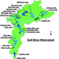 Gull River watershed.png 600 × 600; 56 KB
-
 Madawaska Fish Map.png 4,276 × 1,196; 320 KB
-

-
 Map of Woodbridge, Ontario, 1878.jpg 720 × 620; 255 KB
-

-
 Plan of Mr. Dawson’s Road from Thunder Bay to Lake Shebandowan (1871).jpg 1,024 × 763; 240 KB
-
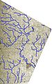
 Township of Collingwood, Grey County, Ontario, 1880 -- watercourses traced in blue.jpg 2,981 × 4,275; 3.82 MB
-
 Township of Normanby, Grey County, Ontario, 1880 -- watercourses traced in blue.jpg 3,324 × 3,226; 2.64 MB
-
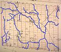
 Watercourses of Adjala Township, Simcoe County, Ontario, 1880.jpg 2,766 × 4,242; 2.53 MB
-
 Watercourses of Albion Township, Peel County, Ontario, 1880.jpg 2,663 × 4,249; 5.58 MB
-
 Watercourses of Tecumseth Township, Simcoe County, Ontario, 1880.jpg 3,856 × 3,289; 2.8 MB
-
 Watercourses of West Gwillimbury Township, Simcoe County, Ontario, 1880.jpg 3,427 × 4,352; 4.89 MB
-
 Watershed of Big Creek, Ontario -b.jpg 255 × 352; 33 KB
_(14578570668).jpg)


.jpg)

_-_C.O.Sen%C3%A9cal,_Geographer_%26_Chief_Draughtsman_;_O.E._Prud%27homme..._-_btv1b53070893g.jpg)

.jpg)


._Carte_copi%C3%A9e_sur_celle_trac%C3%A9e_par_le_sauvage_Ochagach_et..._-_btv1b10105428k.jpg)