Category:Maps of the history of Albania
Jump to navigation
Jump to search
Countries of Europe: Albania · Andorra · Armenia‡ · Austria · Azerbaijan‡ · Belarus · Belgium · Bosnia and Herzegovina · Bulgaria · Croatia · Cyprus‡ · Czech Republic · Denmark · Estonia · Finland · France‡ · Georgia‡ · Germany · Greece · Hungary · Iceland · Republic of Ireland · Italy · Kazakhstan‡ · Latvia · Lithuania · Luxembourg · Malta · Moldova · Montenegro · Netherlands‡ · North Macedonia · Norway · Poland · Portugal‡ · Romania · Russia‡ · Serbia · Slovakia · Slovenia · Spain‡ · Sweden · Switzerland · Turkey‡ · Ukraine · United Kingdom
Limited recognition: Abkhazia‡ · Kosovo · South Ossetia‡ · Transnistria · Northern Cyprus‡
‡: partly located in Europe
Limited recognition: Abkhazia‡ · Kosovo · South Ossetia‡ · Transnistria · Northern Cyprus‡
‡: partly located in Europe
Subcategories
This category has the following 5 subcategories, out of 5 total.
Media in category "Maps of the history of Albania"
The following 17 files are in this category, out of 17 total.
-
 Albania mid XVth century AD.png 2,349 × 2,947; 627 KB
-
 AlbanianpashaliksV2.png 7,489 × 6,888; 1.28 MB
-
 Balcans - Cambiaments territòriaus en 1912-1913.png 1,257 × 1,221; 392 KB
-
 Battlemap.png 1,003 × 752; 195 KB
-
 Capture of Berat 1914.jpg 696 × 566; 201 KB
-
-
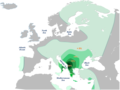 HgE1b1b1a2.png 1,013 × 758; 171 KB
-
 Historicka mapa obce Častkovce.png 891 × 903; 2.25 MB
-
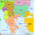
 League of Prizren Map.png 1,839 × 1,652; 479 KB
-
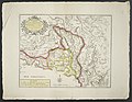
 Map Albania 1930 - Touring Club Italiano CART-TRC-05.jpg 5,562 × 7,384; 5.79 MB
-
 Princedom of Albania (Arbëria).png 800 × 1,004; 172 KB
-
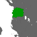 Republic of central albania.png 2,560 × 2,560; 110 KB
-
 Spartizione territoriale della Jugoslavia nel 1941.png 1,047 × 894; 122 KB
-
 The four Albanian Vilavets during the Ottoman Empire (1878).jpg 482 × 706; 45 KB
-
 Torv.jpg 1,003 × 752; 107 KB
-
 Vlora1573.jpg 440 × 314; 45 KB
-


.png)


.jpg)


.jpg)