Category:Old maps of Vorarlberg
Jump to navigation
Jump to search
States of Austria:  Burgenland ·
  Carinthia ·
  Lower Austria ·
  Salzburg ·
  Styria ·
  Tyrol ·
  Upper Austria ·
  Vienna ·
  Vorarlberg
Use the appropriate category for maps showing all or a large part of Vorarlberg. See subcategories for smaller areas:
| If the map shows | Category to use |
|---|---|
| Vorarlberg on a recently created map | Category:Maps of Vorarlberg or its subcategories |
| Vorarlberg on a map created more than 70 years ago | Category:Old maps of Vorarlberg or its subcategories |
| the history of Vorarlberg on a recently created map | Category:Maps of the history of Vorarlberg or its subcategories |
| the history of Vorarlberg on a map created more than 70 years ago | Category:Old maps of the history of Vorarlberg or its subcategories |
Deutsch: Karten von Vorarlberg, die älter als 70 Jahre sind.
Subcategories
This category has the following 2 subcategories, out of 2 total.
L
Media in category "Old maps of Vorarlberg"
The following 18 files are in this category, out of 18 total.
-
 Die Baierische Monarchie 1824.jpg 8,595 × 7,162; 20.38 MB
-
 1918 Alemannia sive Svevia Svperior.tif 7,244 × 6,152, 2 pages; 127.57 MB
-

-

-

-
 Charte von Schwaben Tafel 51 Bregenz.jpg 2,140 × 2,626; 4.36 MB
-
 Charte von Schwaben Tafel 60 Bludenz.jpg 2,155 × 2,616; 5.03 MB
-
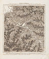
 Charte von Schwaben Tafel 61 Lech.jpg 1,716 × 2,014; 2.96 MB
-
 Chur - 27-47.jpg 3,457 × 4,998; 3.58 MB
-
 De Merian Sueviae 257.jpg 3,924 × 2,663; 1.65 MB
-
 Dornbirner Ache Old Map.jpg 1,390 × 1,533; 1.03 MB
-
 Glurns - 28-47.jpg 3,443 × 4,986; 3.82 MB
-
 Grafschaft Tyrol mit Vorarlberg.tif 5,736 × 4,362, 2 pages; 71.64 MB
-
 Lacus Constantiensis 1540.jpg 1,266 × 1,048; 676 KB
-
 Landvogdey in Schwaben.tif 3,434 × 2,344, 2 pages; 23.08 MB
-

-
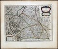
 Reilly 196 HAAB.jpg 1,007 × 719; 628 KB
-
 Vorarlberg-oud2.jpg 1,683 × 2,683; 481 KB

_(14593063447).jpg)
_(14775898191).jpg)
_(14778704982).jpg)


