Category:Remutaka Rail Trail
Jump to navigation
Jump to search
Most pictures of that category result from trailing 2006 (S → N) and 2013 (N → S). Currently they are ordered following the N → S direction.
walking and cycling track  | |||||
| Upload media | |||||
| Instance of | |||||
|---|---|---|---|---|---|
| Located in protected area | |||||
| Location |
| ||||
| Street address |
| ||||
| Heritage designation |
| ||||
| Length |
| ||||
 | |||||
Subcategories
This category has the following 6 subcategories, out of 6 total.
- Cross Creek railway station (11 F)
- Pakuratahi Truss Bridge (9 F)
- Pakuratahi Tunnel (3 F)
- Siberia Tunnel and Swingbridge (10 F)
- Summit railway station (14 F)
- Summit Tunnel (Rimutaka) (9 F)
Media in category "Remutaka Rail Trail"
The following 80 files are in this category, out of 80 total.
-
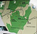 Rimutaka Rail Trail map.jpg 1,613 × 1,481; 581 KB
-
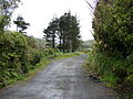
 Rimutaka Rail Trail 01.jpg 1,426 × 958; 650 KB
-
 Rimutaka Rail Trail 03.jpg 1,905 × 1,221; 657 KB
-
 Rimutaka Rail Trail 04.jpg 2,048 × 1,536; 656 KB
-
 Rimutaka gate.jpg 1,878 × 1,188; 652 KB
-
 Rimutaka sign.jpg 1,970 × 1,248; 659 KB
-
 Rimutaka Incline 15.jpg 2,048 × 1,536; 1.36 MB
-
 Rimutaka Rail Trail 08.jpg 2,048 × 1,536; 653 KB
-
 Rimutaka Rail Trail 09.jpg 2,048 × 1,536; 656 KB
-
 Rimutaka Rail Trail 11.jpg 2,048 × 1,536; 651 KB
-
 Pakuratahi River 1.jpg 2,048 × 1,536; 690 KB
-
 Rimutaka Rail Trail 13.jpg 1,536 × 2,048; 663 KB
-
 Rimutaka Rail Trail 14.jpg 2,048 × 1,536; 690 KB
-
 Rimutaka Rail Trail 16.jpg 2,048 × 1,536; 698 KB
-
 Pakuratahi River 2.jpg 1,536 × 2,048; 687 KB
-
 Pakuratahi Tunnel 0.jpg 1,177 × 1,271; 663 KB
-
 Pakuratahi Tunnel 1.jpg 2,048 × 1,536; 663 KB
-
 Pakuratahi Tunnel 2.jpg 2,048 × 1,536; 625 KB
-
 Rimutaka Rail Trail 25.jpg 2,048 × 1,536; 613 KB
-
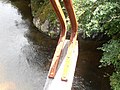
 Truss bridge 0.jpg 1,307 × 1,506; 656 KB
-
 Truss bridge 1.jpg 2,048 × 1,536; 661 KB
-
 Truss bridge 2.jpg 2,048 × 1,536; 661 KB
-
 Pakuratahi Truss Bridge.jpg 1,024 × 768; 334 KB
-
 Truss bridge 3.jpg 2,048 × 1,536; 660 KB
-
 Truss bridge 4.jpg 2,048 × 1,536; 664 KB
-
 Pakuratahi River 3.jpg 1,536 × 2,048; 661 KB
-
 Truss bridge 6.jpg 1,536 × 2,048; 656 KB
-
 Truss bridge 7.jpg 2,048 × 1,536; 656 KB
-
 Truss bridge 8.jpg 2,048 × 1,536; 660 KB
-
 Rounding the Curve.jpg 1,390 × 1,920; 650 KB
-
 View downstream Pakuratahi River from Ladle Bend.jpg 1,024 × 768; 327 KB
-
 Rimutaka Incline 09.JPG 2,048 × 1,536; 1.34 MB
-
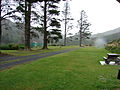
 Summit yard 0.jpg 2,048 × 1,536; 645 KB
-
 Rimutaka Incline 12.jpg 1,632 × 1,224; 868 KB
-
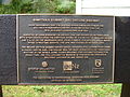
 Rimutaka Incline plaque.jpg 1,221 × 874; 846 KB
-
 Rimutaka Incline 10.jpg 2,048 × 1,536; 1.45 MB
-
 Rimutaka Incline 13.jpg 2,048 × 1,536; 1.32 MB
-
 Summit yard 1.jpg 1,844 × 1,076; 644 KB
-
 Summit yard 2.jpg 1,893 × 1,225; 622 KB
-
 Rimutaka Incline 14.jpg 2,048 × 1,536; 1.38 MB
-
 Summit station 1.jpg 1,988 × 1,418; 633 KB
-
 Summit station 2.jpg 1,726 × 1,407; 643 KB
-
 Rimutaka Incline 11.jpg 2,048 × 1,536; 1.32 MB
-
 Summit station 4.jpg 2,048 × 1,536; 695 KB
-
 Rimutaka Incline 08.JPG 1,632 × 1,224; 861 KB
-
 Summit Tunnel 2.jpg 1,460 × 1,012; 653 KB
-
 Summit Tunnel 4.jpg 2,048 × 1,536; 658 KB
-
 Summit Tunnel 6.jpg 1,536 × 2,048; 659 KB
-
 Summit Tunnel 7.jpg 1,536 × 2,048; 655 KB
-
 Rimutaka Incline 07.JPG 1,632 × 1,224; 843 KB
-
 Summit Tunnel 9.jpg 1,337 × 1,398; 647 KB
-
 Rimutaka Rail Trail- Summit Tunnel.jpg 5,364 × 3,576; 13.65 MB
-
 Rimutaka Rail Trail- Siberia Tunnel.jpg 5,616 × 3,744; 13.34 MB
-
 Siberia Tunnel 2.jpg 1,819 × 1,478; 649 KB
-
 Siberia Tunnel 1.jpg 1,747 × 1,419; 621 KB
-
 Rimutaka Rail Trail- Siberia Tunnel - 9991928504.jpg 5,616 × 3,744; 12.89 MB
-
 Siberia Tunnel 4.jpg 2,048 × 1,536; 704 KB
-
 Siberia Tunnel and Swing bridge.jpg 2,048 × 1,536; 680 KB
-
 Rimutaka Incline 06.JPG 1,632 × 1,224; 888 KB
-
 Siberia Swing Bridge 2.jpg 1,957 × 1,426; 663 KB
-
 Siberia Swing Bridge 3.jpg 1,943 × 1,414; 639 KB
-
 Siberia Swing Bridge 4.jpg 1,451 × 1,869; 633 KB
-
 Cross Creek.jpg 2,048 × 1,536; 629 KB
-
 Rimutaka Incline 04.JPG 1,632 × 1,224; 861 KB
-
 Rimutaka Incline 05.JPG 1,632 × 1,224; 862 KB
-
 Price's Tunnel.jpg 1,357 × 1,448; 612 KB
-
 Nature's reroute.jpg 1,365 × 1,910; 612 KB
-
 Rimutaka accident 1880.jpg 1,536 × 2,048; 656 KB
-
 The Long Straight.jpg 1,536 × 2,048; 655 KB
-
 Rimutaka fires.jpg 1,536 × 2,048; 654 KB
-
 Rimutaka Incline 01.JPG 2,048 × 1,536; 1.44 MB
-
 Cross Creek station 1.jpg 2,048 × 1,536; 654 KB
-
 Cross Creek station 2.jpg 1,931 × 1,432; 653 KB
-
 Cross Creek welcome 1.jpg 2,048 × 1,536; 671 KB
-
 Cross Creek welcome 2.jpg 2,048 × 1,536; 672 KB
-
 Rimutaka Incline 03.JPG 1,632 × 1,224; 892 KB
-
 Cross Creek turntable pit.jpg 1,632 × 1,224; 886 KB
-
 Fisherman's Rock, Remutaka Great Ride.jpg 4,889 × 2,266; 4.06 MB
-
 Wild Coast Track at Ōrongorongo.jpg 4,032 × 3,024; 5.84 MB
-
 Ōrongorongo river mouth.jpg 7,091 × 2,801; 6.99 MB


